Sedona UHD Airport and Surrounding Terrain/Features
Introduction
Sedona brings thoughts of the meta-physical world and the amazing beauty in the rock formations and canyon to anyone who has been there or read about it. Being in the region called the “Southwest” in the U.S., it’s typical of the region in being hot, dry and arid desert punctuated by creeks and rivers that flow through it- Sedona is located in one of those green areas where the creek has formed a canyon with geological features.
X-Codr has produced an update to his existing X-Plane scenery of Sedona airport and surrounding areas. I’m starting this review by quoting portions of the included manual (with permission), as it sets the tone well for what follows in this review.
“Sedona Airport (KSEZ) is located two miles southwest of the town of Sedona Arizona, and it sits atop a high mesa providing great views of the stunning valley around it. The airport is home to 57 hangars, an FBO, a restaurant, two air tour companies, and a nearby hotel. Fuel, GPU, tie down, hangar, and lavatory services are offered. ….
Sedona UHD is a project to provide the best experience for flights at the Sedona Airport. In November twenty seventeen, the first version was released, which was later followed by several small updates. One year later, in late December twenty eighteen, the major Sedona UHD version one dot five was announced.
This was a major update that nearly completely re modeled the airport in higher quality and added lots of new features such as a custom town, custom models of Bell Rock, Courthouse Butte, Cathedral Rock, and sound and particles through the proprietary X-Codr Designs Scenery Technology X which incorporates the SoundXP plugin and Particle Access XP plugin. This update was released free in February twenty nineteen as a gift to all the users that supported my product when I entered the payware market.“
The manual includes recommended graphics settings and system specifications, a full list of features, installation, a high performance patch, instructions regarding using your own mesh (if applicable) and tech support / credits.
X-Codr’s forum can be found at the dedicated X-Plane.Org forum where a quick response to any questions is the norm. Wikipedia tells us that Sedona is a city that straddles the county line between Coconino and Yavapai counties in the northern Verde Valley region of the U.S. state of Arizona. As of the 2010 census, its population was 10,031. Sedona’s main attraction is its array of red sandstone formations. The formations appear to glow in brilliant orange and red when illuminated by the rising or setting sun. The red rocks form a popular backdrop for many activities, ranging from spiritual pursuits to the hundreds of hiking and mountain biking trails.
The majestic red rock scenery and evergreen vegetation are two reasons for the unique energy of Sedona and its tangible regenerative and inspirational effects. … Sedona is also internationally known for the uplifting power of its Vortex meditation sites (Sedona vortexes are thought to be swirling centers of energy that are conducive to healing, meditation and self-exploration).
The red rocks of Sedona are formed by a unique layer of rock known as the Schnebly Hill Formation. The Schnebly Hill Formation is a thick layer of red to orange-colored sandstone found only in the Sedona vicinity. The sandstone, a member of the Supai Group, was deposited during the Permian Period. See more at the dedicated Wikipedia page.
I have been to Sedona, but drove there rather than flying. Sedona is in a canyon that is cut into the otherwise flat terrain by Oak Creek. When approaching the area, like the Grand Canyon, there is no visible evidence of where Sedona is until you get to the rim and look down at the town and amazing canyon walls. There are some areas within the canyon that have not been eroded by the creek- these appear as monoliths the rise from the canyon floor to elevations closer to that of the surrounding flat area in the region. Many of them are partially eroded and appear as highly sculptured rock features.
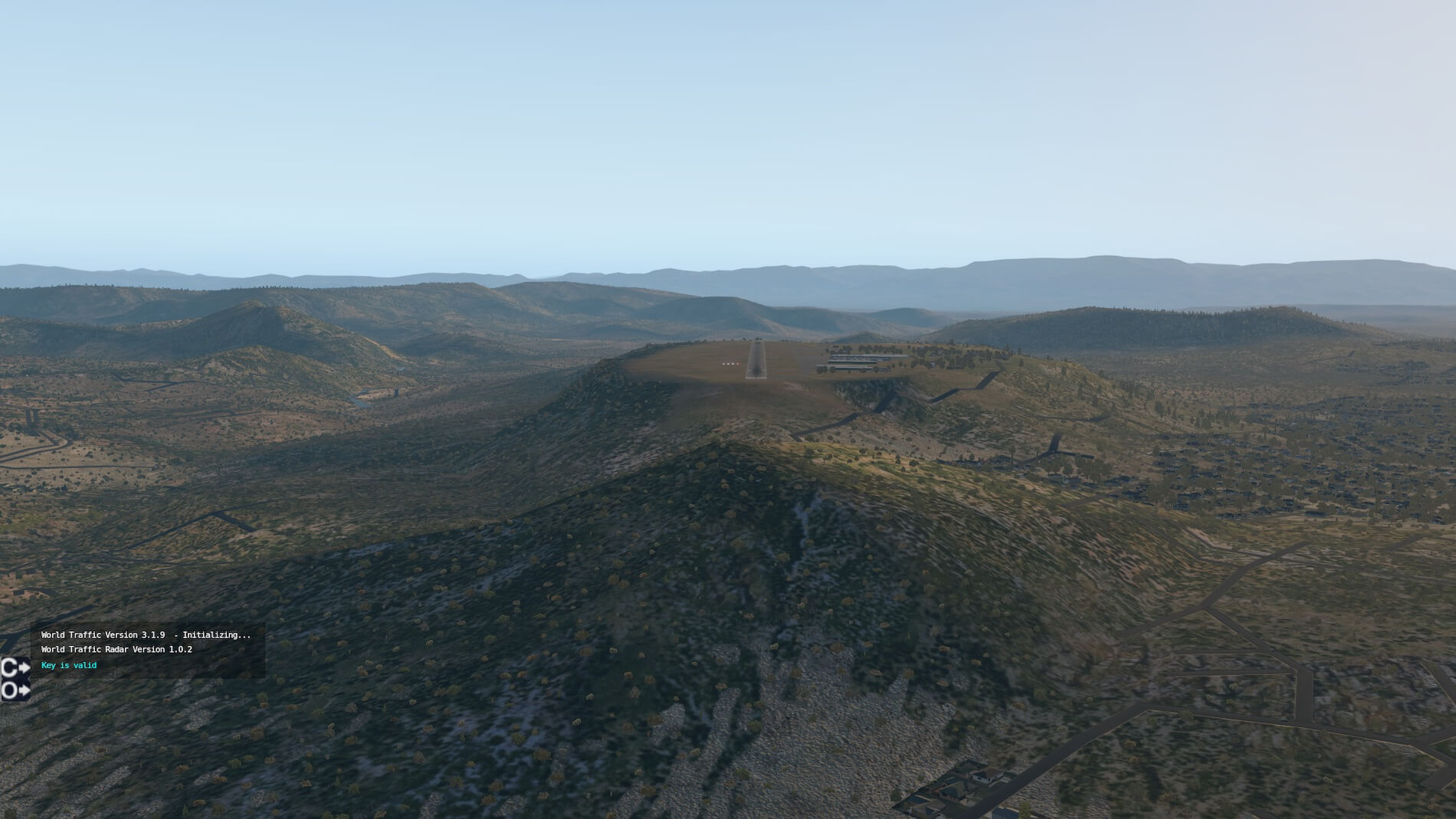
Like many small cities in the U.S., Sedona has an airport- it occupies one of the above monoliths that is elevated above the canyon floor and is reasonably flat- the runway has a 1.83 percent gradient. It is uncontrolled (no control tower), with a single runway of 5,129 feet (03 / 21). The airport is on a mesa with sharp drop-offs at each end of the runway (hence no runway expansion is possible !!). There is one instrument approach, GPS 03, and one obstacle departure procedure (ODP) for runway 21.
There is a PAPI on both runways 03 and 21, plus an AWOS. Other than these features, which themselves define a rather sparse and small airport, there isn’t much else other than hangers, a small shared terminal and a very nice restaurant/bar. Sedona is only 116 miles (187 km) from Phoenix, a 2 hour drive, where a very large airport exists, so there is little demand for passenger air service to this area.
I was excited when Angelique asked me to do this review of Sedona UHD by X-Coder. He is the author of KDEN that we also did a review on earlier this year. KDEN is a leviathan in comparison to this small airport, so one might ask why the excitement to do such a small airport review. Firstly, I have been to Sedona (as already mentioned), and have seen it’s magic! Secondly- it’s that magic- amazing rock formations with incredible red colors in the rocks- the colors actually change as the earth rotates throughout the day and causes the sun to “move” across the sky. The rock formations sometimes look like large objects, such as those that are appropriately named Cathedral Rock, Courthouse Butte and Bell Rock, among others. Check out these links I and II.
The deep red color for which Sedona is famous is due to the presence of hematite (iron oxide, otherwise known as rust) that stains the sandstone of the Schnebly Hill and Hermit Shale layers. The steepness of the terrain is due the fact that the top layers of the strata are composed of basalt and limestone, which are harder than the underlying sandstone. Water running off the edge of the escarpment eats away at the lower layers, creating the shear cliffs.
Eventually enough soft material is weathered away that it undercuts the cap layer, which subsequently breaks off in large slabs and falls into the canyons. This exposes new soft material and the process starts again, with the cliff face now twenty-odd feet further north than it was before.
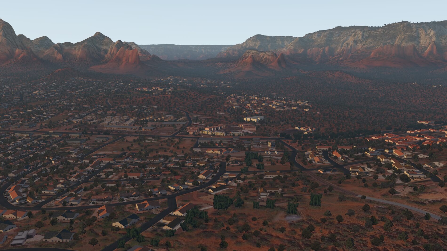
I am dividing this review into two portions. Firstly, the airport infrastructure, then the graphical representation of the rock formations in the vicinity of the airport that would be visible on approach.
Sedona Airport SEZ/KSEZ
This is not a large airport- one runway 03 / 21 which is 5,129 feet 1.56 km) and only 100 feet in width. There is no control tower. The airspace is uncontrolled (Class G), with controlled airspace (Class E) beginning at 700 feet above the airport- this is typical of many small uncontrolled airports throughout the US. The airport is at an elevation of 4,830 feet above mean sea level (MSL).
Looking at the Chart Supplement, some useful information is available. There are warnings of turbulence, especially when approaching runway 21 with a significant southwest wind where strong downdrafts are probable to the north-east of the approach end of the runway. No “touch-and-goes” due to this being a noise sensitive area. The “calm wind” (preferred) runway is 03, although looking at the takeoff minimums (mandatory for Part 135 / Part 121 operations), runway 03 is not authorized. (We will see why that is shortly).
For runway 21 there is an Obstacle Departure Procedure (ODP) that allows for standard takeoff minimums of 1 statute mile for aircraft with two engines or less, or 0.5 statute mile for those having more than two engines. as long as the RNAV procedure is followed. Like all RNAV ODP’s, this comes in the form of a graphical representation (note RNAV may be just textual, graphical, or both). However, it is not a SID so may not be included in any IFR clearance. Runway 3 is not authorized for take-offs due to obstacles, where minimums need to be considered, I assume for Part 135 and 121.
There are no approach light systems. There are “runway end identifier lights” at both ends of the runway, and “Medium Intensity Runway Lighting” (MIRL). Radio frequencies are 118.525 MHz for the AWOS, 123.0 for the Common Traffic Airport Frequency (CTAF), and Phoenix Approach / Departure on 126.375. There is a Precision Approach Path Indicator (PAPI) light system at each end of the runway, however a remark in the Chart Supplement tells us that the runway 21 PAPI is unusable beyond 2 nautical miles from the approach end.
There are many words of caution in the information above, as anyone who is used to evaluating airport information will be aware. So- let’s take a look at both the airport topography and what X-Codr has done with the graphics for this airport.
Scenery Package | Airport and Environment
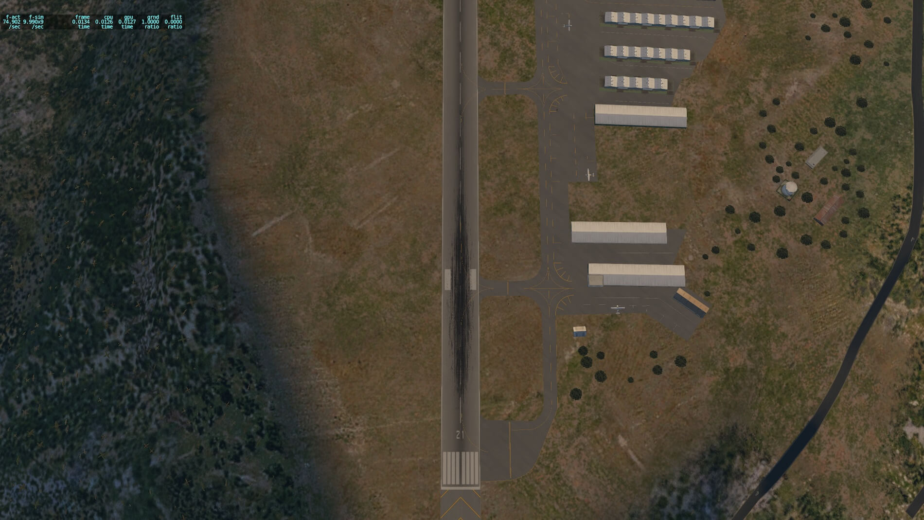
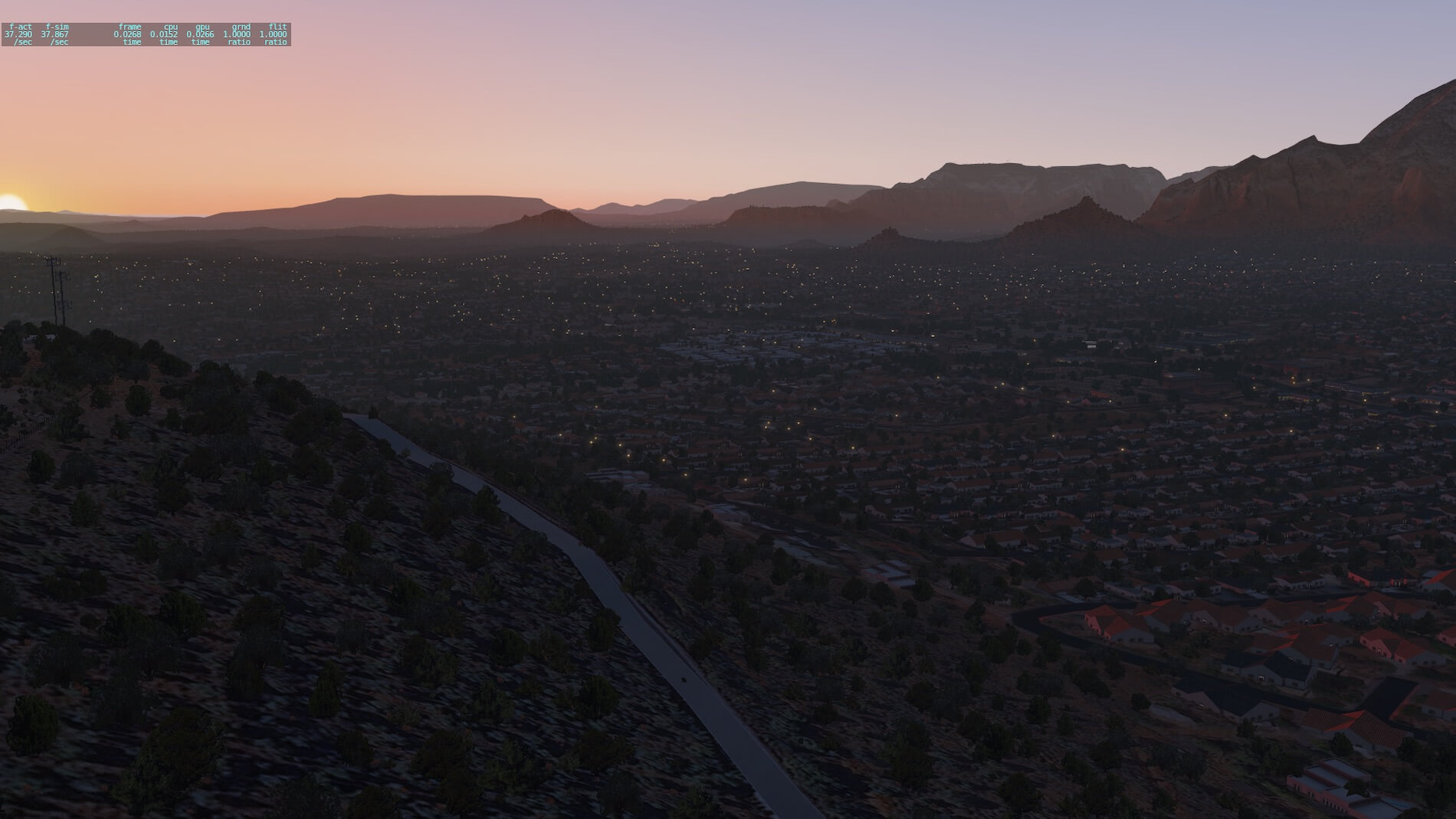
The following two screenshots are taken from a saved situation. The one on the left is the stock scenery, the one on the right the X-Codr UHD scenery. Both show an approach to runway 21 at KSEZ. In both screenshots it’s obvious why all those warnings were in the airport information that we just reviewed. The rising terrain just short of the runway 21 threshold might explain why the PAPI has visibility restrictions, and would certainly explain the updrafts and downdrafts when the wind is out of the south-west.
The entire airport is on a mesa with sharp drop-offs adjacent to both ends of the runway. This airport should certainly be in a list of those with difficult approaches!! The potential for turbulence and visual allusions is significant.

However- the similarities between both versions ends right there. I had to do a “double-take” and question if I was at the same airport when comparing these two versions. It’s not often that someone changes the entire environment as well as the airport.
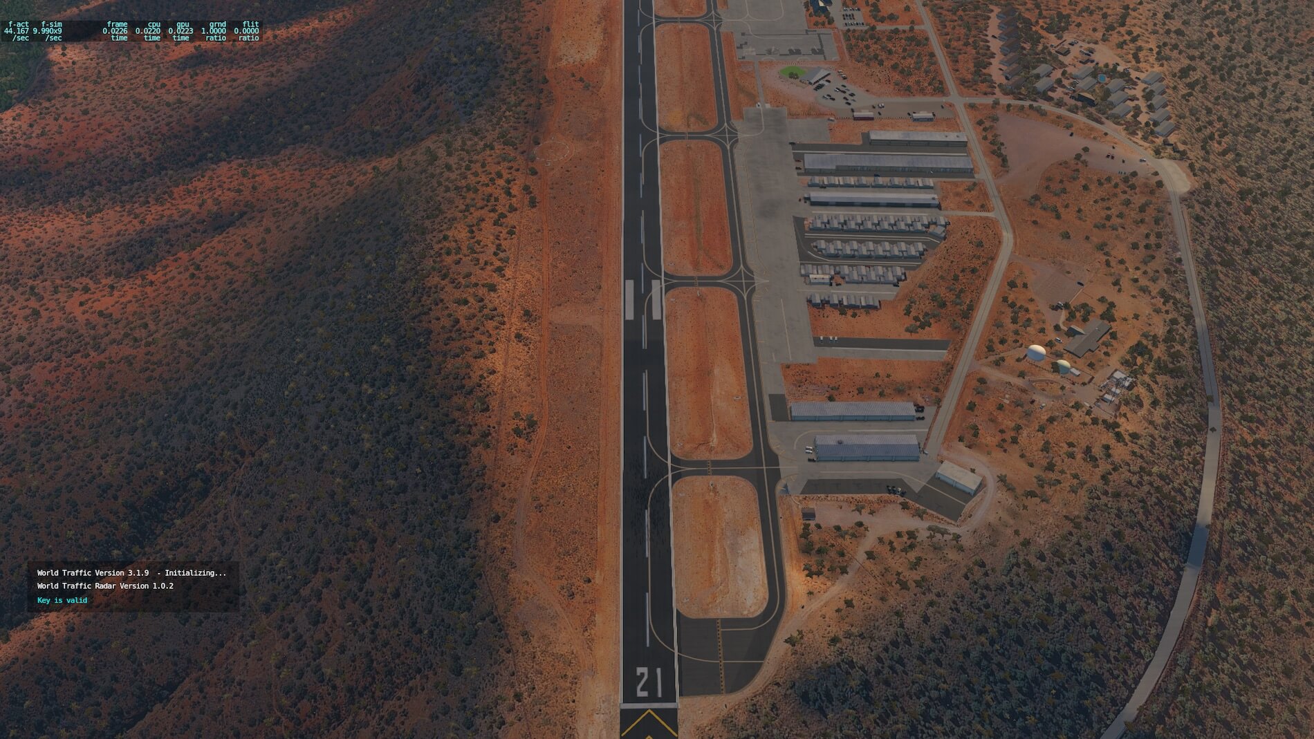
To be clear, I never had the mesh installed with the default scenery, it’s included in the package from X-Codr, so to be fair there are comparisons between the default and the addon scenery beyond that may not exist for those already using a mesh. Looking at the first comparison (default on top, X-Codr version below it), the first comparison is the red coloring- which having been there is true to form in the add-on scenery. Then, to the mid-left of the screen there is a sharp vertical cliff that surrounds an obelisk.
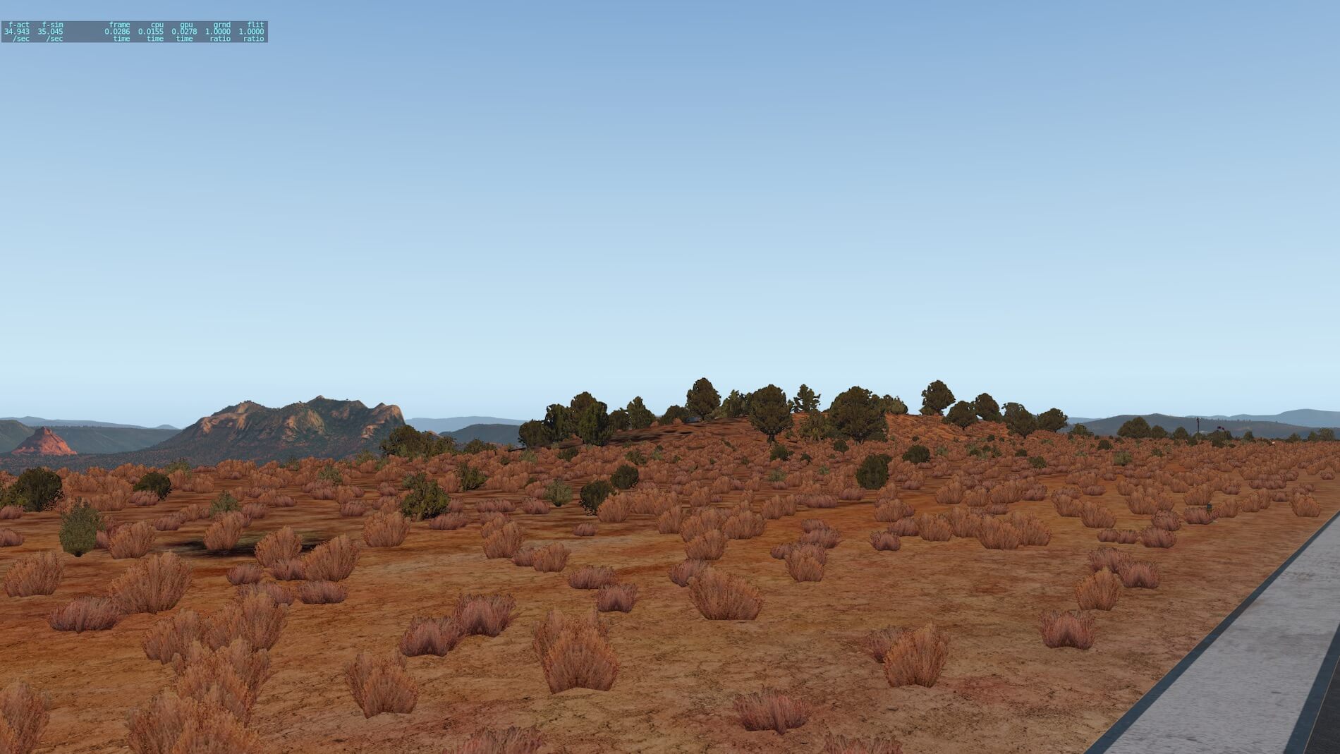
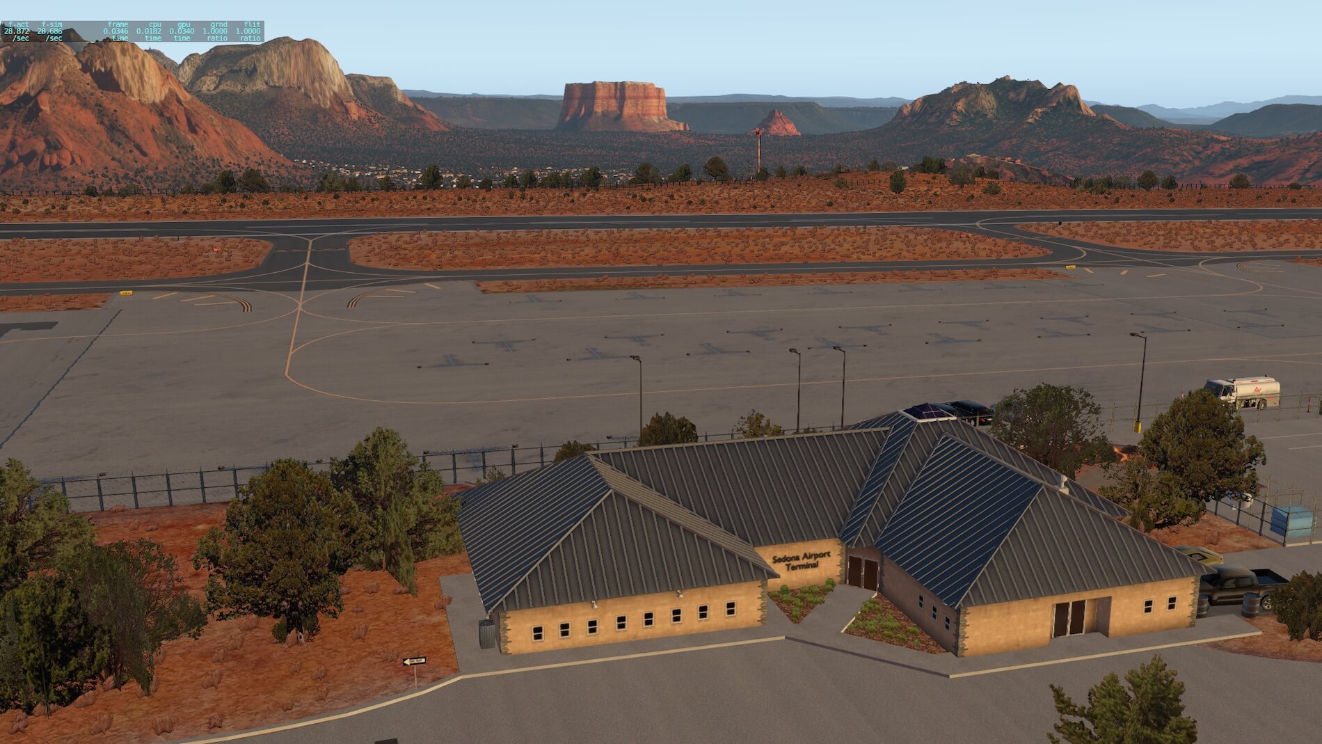
This, again, is true to form in the addon, as is the many small buildings to this side of the rock feature. There is more vegetation near the runway threshold, which is well done as it truly represents that sparse native growth in the semi-arid desert land. I like the red roofs in the foreground lower right, typical of the building style having tiled roofing to help deal with the sun’s heat.
I then attempted a comparison of the airport environment, looking down on the runway from a height where I could also see the airport infrastructure surrounding the runway. Once again, the visuals are almost incomparable. There is much more detail in the X-Codr rendition, however having never flown into this airport (and therefore not been able to access the operational areas), I found it hard to tell which is more realistic. X-Codr’s version certainly looks better, but is it more accurate.
I found an airport diagram on-line but it didn’t show enough detail to compare with. I eventually went to a satellite map and zoomed into the airport area, which confirmed that the addon scenery is more accurate.
I did notice at least one technical discrepancy between the stock and addon runway markings. On runway 21, the aiming point marking is in a different location on the runway. Once again, looking at the satellite map, X-Codr’s scenery package is more correct. Note that the aiming point marker should be 1,020 feet beyond the threshold- that’s related to the 1:20 ratio that defines the 3-degree glidepath, where the distance to the aiming point is approximately 20 times the height above the threshold (50 feet). – I could have gotten more technical and measured the number of runway centerline markings to confirm this, but I didn’t (there is 1 centerline stripe at every 200 feet on a standard runway).
Having established and hopefully communicated the differences in the scenery, I am not making any other visual comparisons (I think you get the picture by now, lol ), but rather showing airport features only from the addon scenery.
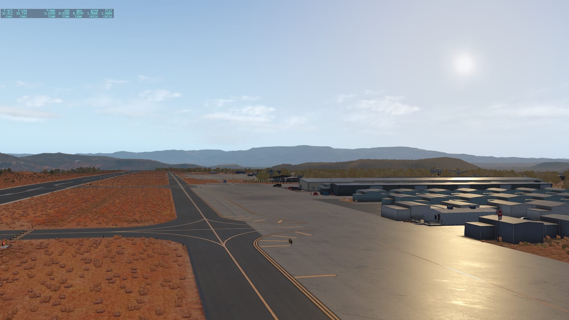
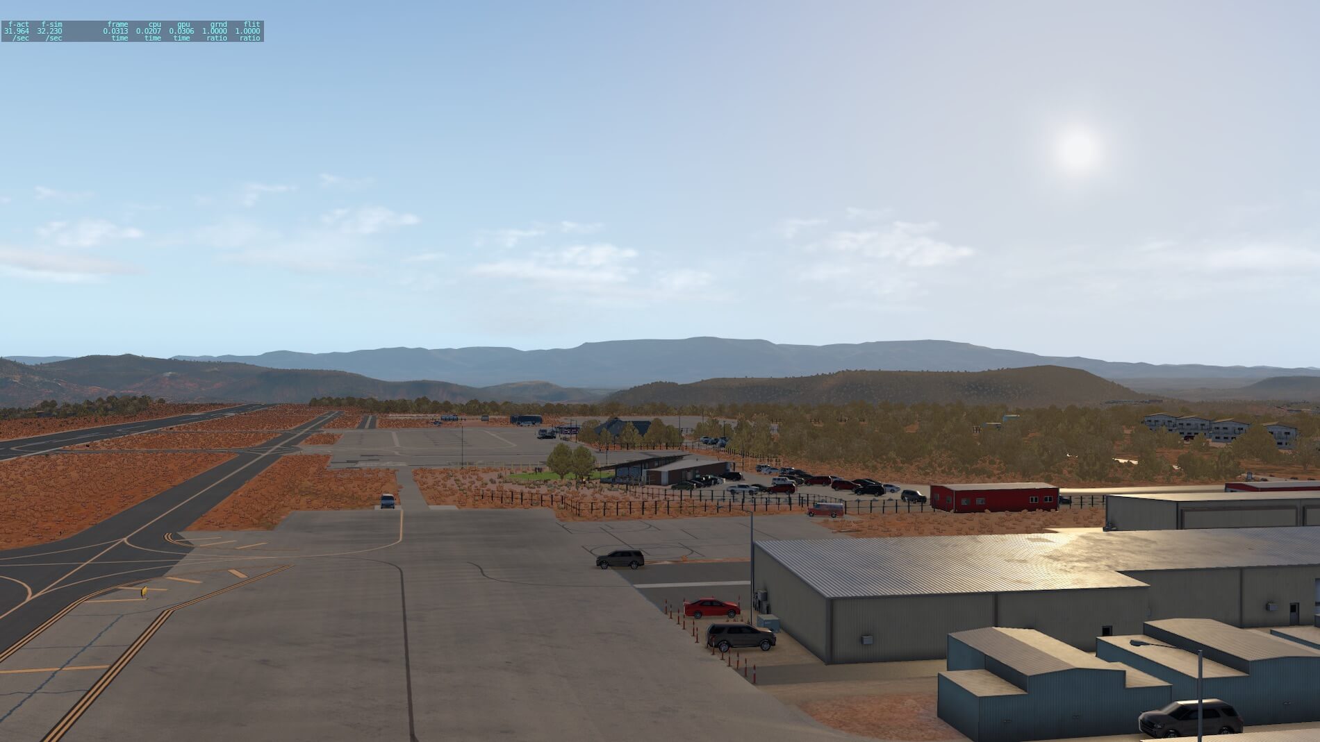
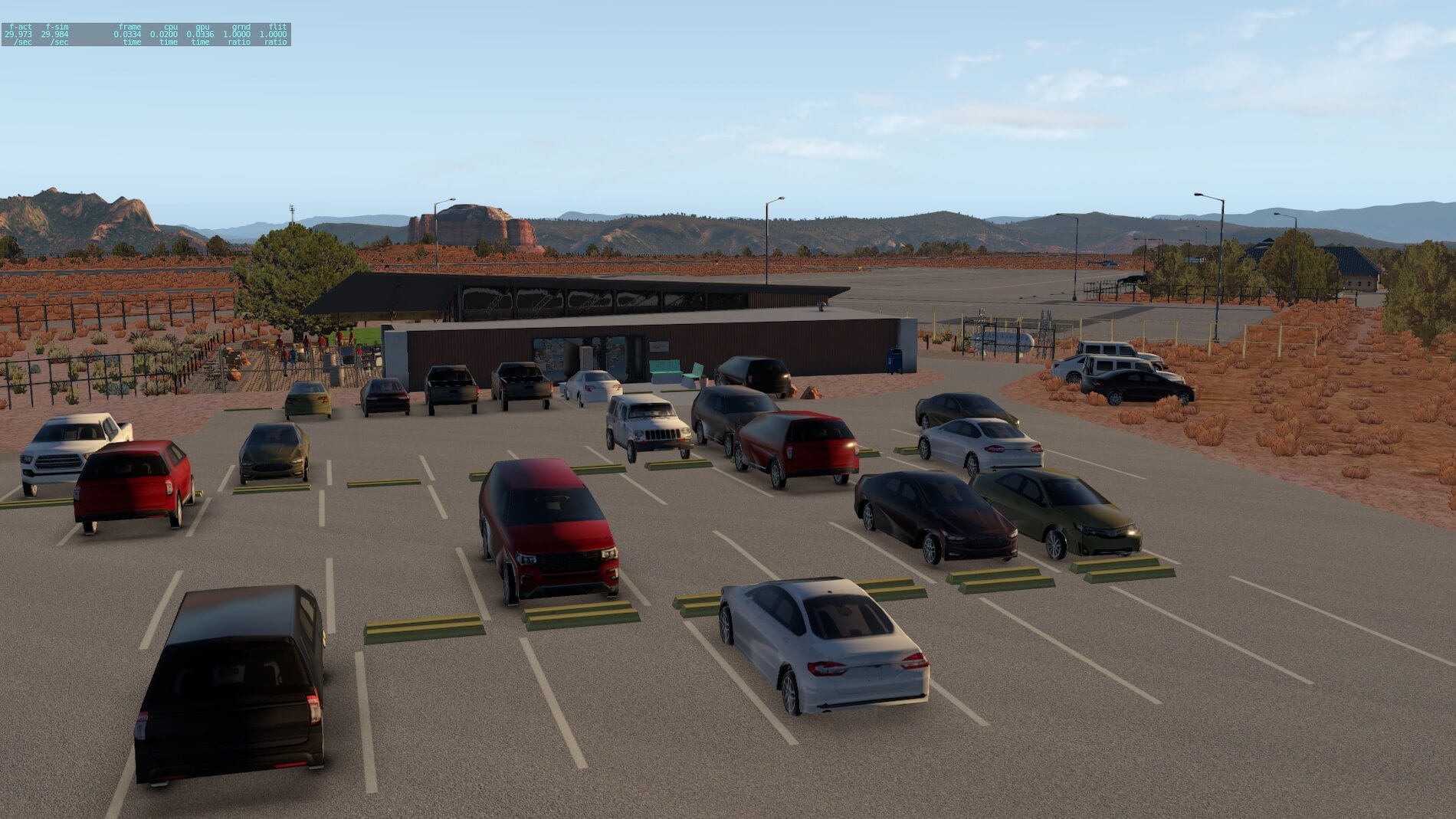
The following screenshots show firstly the attention given to the runway 21 texturing, the odd clumps of grass (which are actually there!), and the hanger buildings. There is a lot of detail in this shot. And the vast drop-off at the far end of the runway can be seen (more on this soon. A similar view displaced to the side above the taxiway (21), and further to the north-west (perpendicular to the runway that shows even more details in cars parked at the FBO / restaurant. A small patch of green appears on the runway side of the restaurant, nicely done!

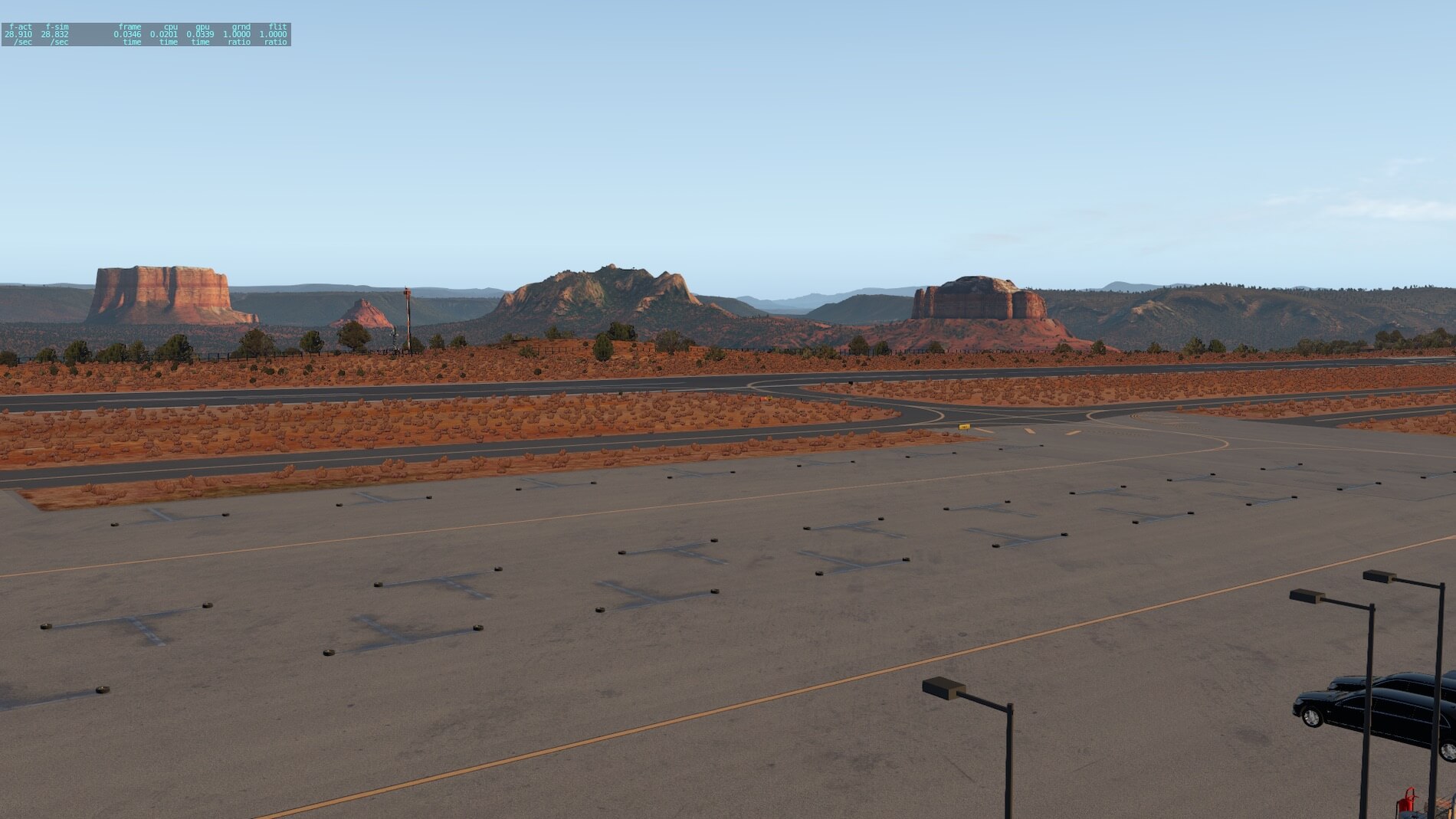
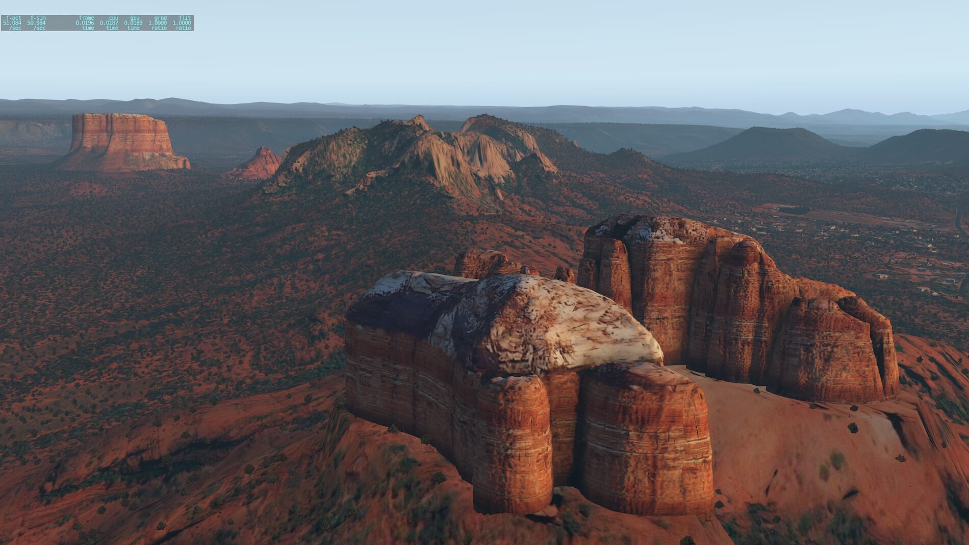
Moving along the apron and looking across the runway we see some of the beautiful monoliths- areas of rock that were not eroded to the base of the canyon, but eroded enough to give some features to the rock formations. Once again, X-Codr has done a great job in the representation of these shapes, and the color he has used.
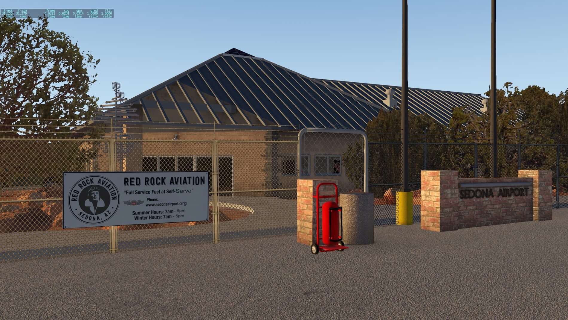
At this time of day you can see that some of the monoliths are in shadow and some have a low angle direct sunlight- I purposefully set the time of day to be approaching dusk so that I could verify the changes in color of the rock formations as the sun gets lower in the sky- and this picture lives up to reality right here! The Red Rock Aviation building is well signed, along with the Sedona Airport insignia. And “standing” on the runway to give you an idea of the roughness of the terrain once again tussocks of grass as well), and some 3D trees (more on the trees at the end of the review).
The drop-off at the 03 end of the runway is very visible in this next screenshot, as is the windsock and segment circle, the airport beacon and a radio mast. Moving closer to that airport beacon and looking down to the canyon base is stunning stuff- there’s some of the town represented, but that massive monolith is so prominent in all of it’s raw beauty. It’s presence almost dwarfs the airport and other nearby features. I could use this screenshot as a desktop wallpaper image, it combines the presence of aviation with the stark unforgiving dryness of the American south-west, as well as the geological wonder of the monolith, all carved out over the millennia by the scarce water supplies in this region. Once again, the colors are amazingly true to form.
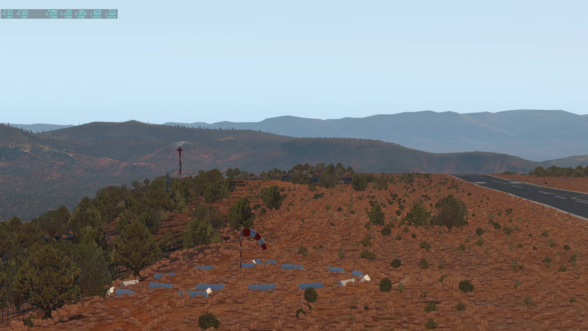
Ok, it’s a bit of letdown to go to some parked cars after that previous screenshot, but we do it to show the airport detail. I can’t be too sure why these cars are bounded by red and white poles- do they ever move? The brown SUV appears to be skewered by a red and white pole. Some hangers with doors in various positions, cleverly done.

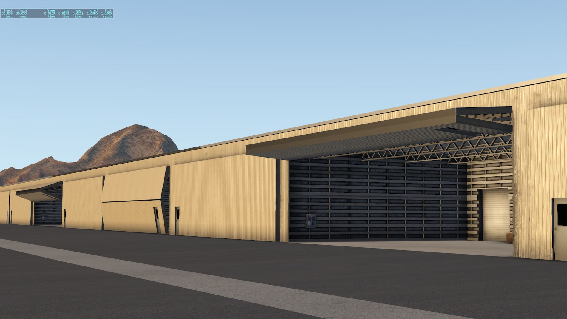
Speaking of hangers, two of the hangers have dynamic doors, triggered by the time of day. Both have start-up locations in the X-Plane 11 Location / Ramp menu list. I played around for a bit with one of them (labelled “Hanger 9AM-5PM”) to capture the door opening- unrealistically I was in the stock Cessna 172 with the engine running and the hanger door closed, inside the hanger- please don’t try to do this in real life as it might have unanticipated consequences!! Sure enough, when the time was 1500 Zulu, the bi-fold hanger door raised up in a smooth and gradual fashion.
Very nice!
X-Codr says he may add an aircraft proximity feature in the future.


So much for some airport infrastructure- more of that to come. Back to the scenic wonders of Sedona, once again taken from the airport. From taxiway A4 (well signed) looking again at that monolith in the distance and the surrounding hills. In these shots the sun is setting even further. A wider shot from above the airport terminal in the same direction. Now pivoting clockwise to show both more airport infrastructure, but also more of the surrounding terrain.


Now we venture outside of the airport perimeter to a location that I stayed in Sedona. It’s within a few hundred meters of the airport and is actually a resort. I took this screenshot of the mountains, looking north-west, and compared it to a photo of my own (at the end of this review). In the center right is a hiking trail and an overlook, shown in closer up in the following screenshot. It’s actually like this- the rocks on the side of the road are placed to “fence off” the overlook. The town can be seen below.


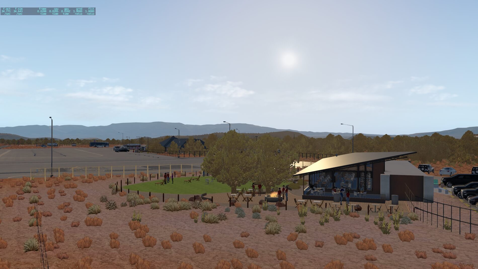
Back to the airport restaurant where we ate most of our evening meals (it saved having to drive down to the town to find somewhere to eat). The restaurant car park and entrance, then several screenshots showing that green grassy area where there is a barbeque or firepit. Once again, it actually exists!!


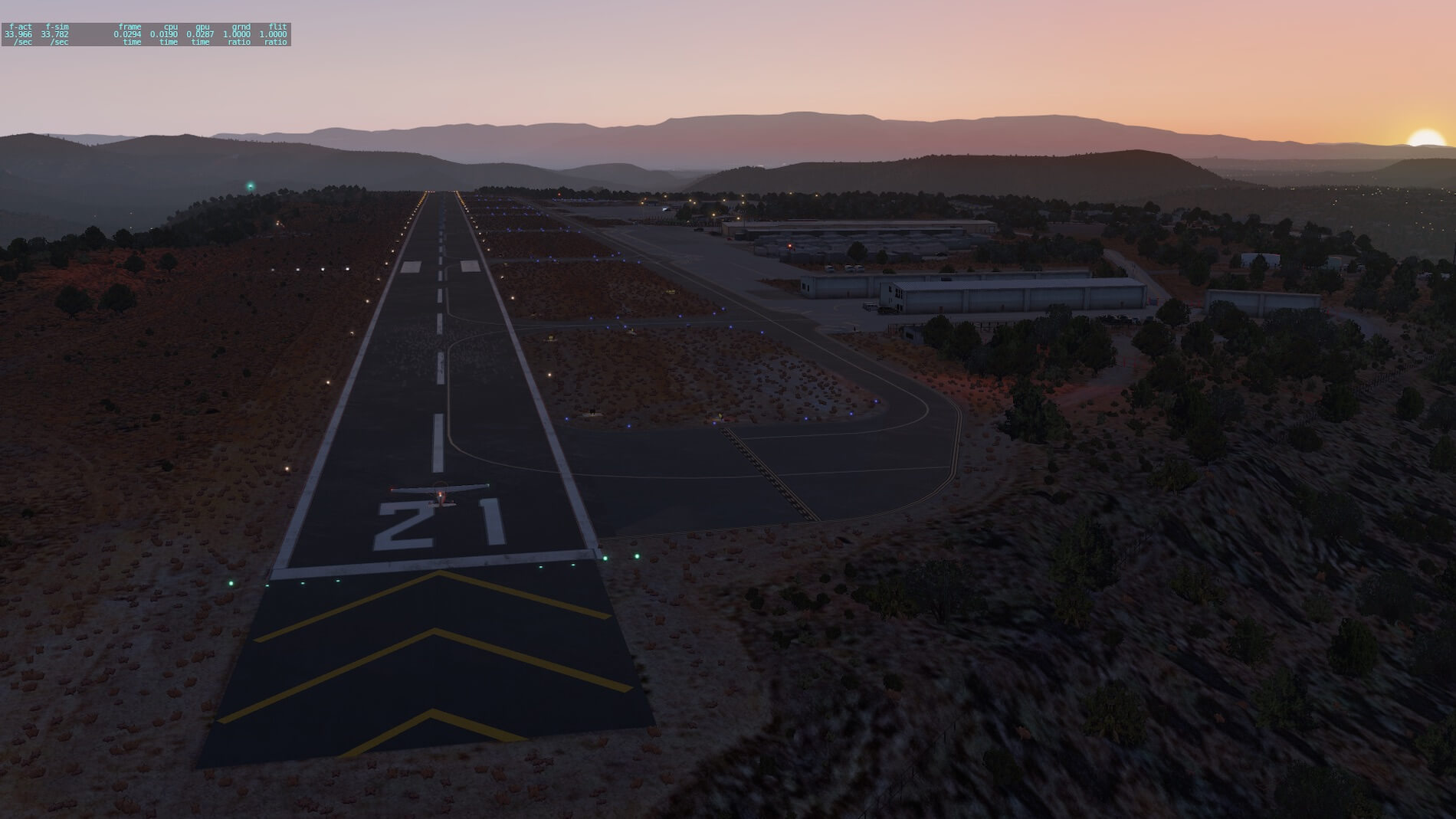
Finally, as far as the airport is concerned, waiting for the sun to almost set and showing some of the reflective textures from the sunset- both at the airport (with runway / taxiway lighting), and looking to the amazing and colorful geology in this area. In reality the colors of the rock change minute by minute as the sunsets, and while we can’t expect that of an X-Plane 11 scenery pack, this addon does that sea change of color justice, within the limitations of the simulator.


Surrounding Scenery
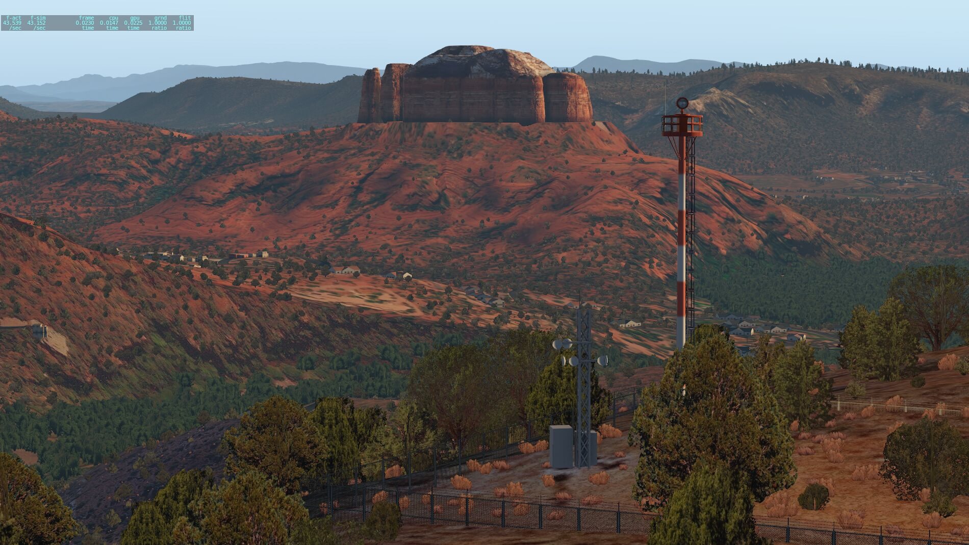
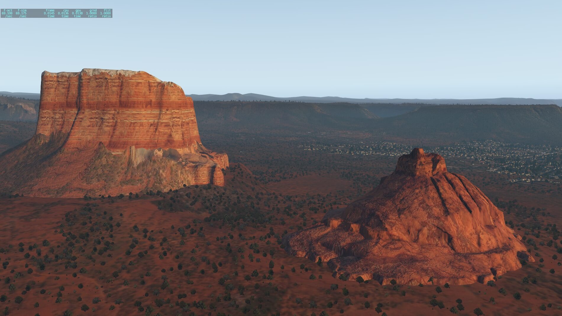
Once again, pressing the “C” key allows us to decouple from the aircraft axes and move independently through the scenery. I’ve shown some screenshots below of the surrounding territory around Sedona- most of which it is well renowned for. The first screenshot shows the major rock formations- Cathedral Rock in the foreground, with Courthouse Butte in the background (well illuminated by the late afternoon sun), and with Bell Rock just to right of it- Bell Rock is lower in elevation so harder to see.
I have only seen these from a distance but my opinion is that they are a good rendition of the actual features. The next screenshot shows Courthouse Butte and Bell rock from a much closer perspective, with some of the town in the background. The same attention to detail has been shown here.
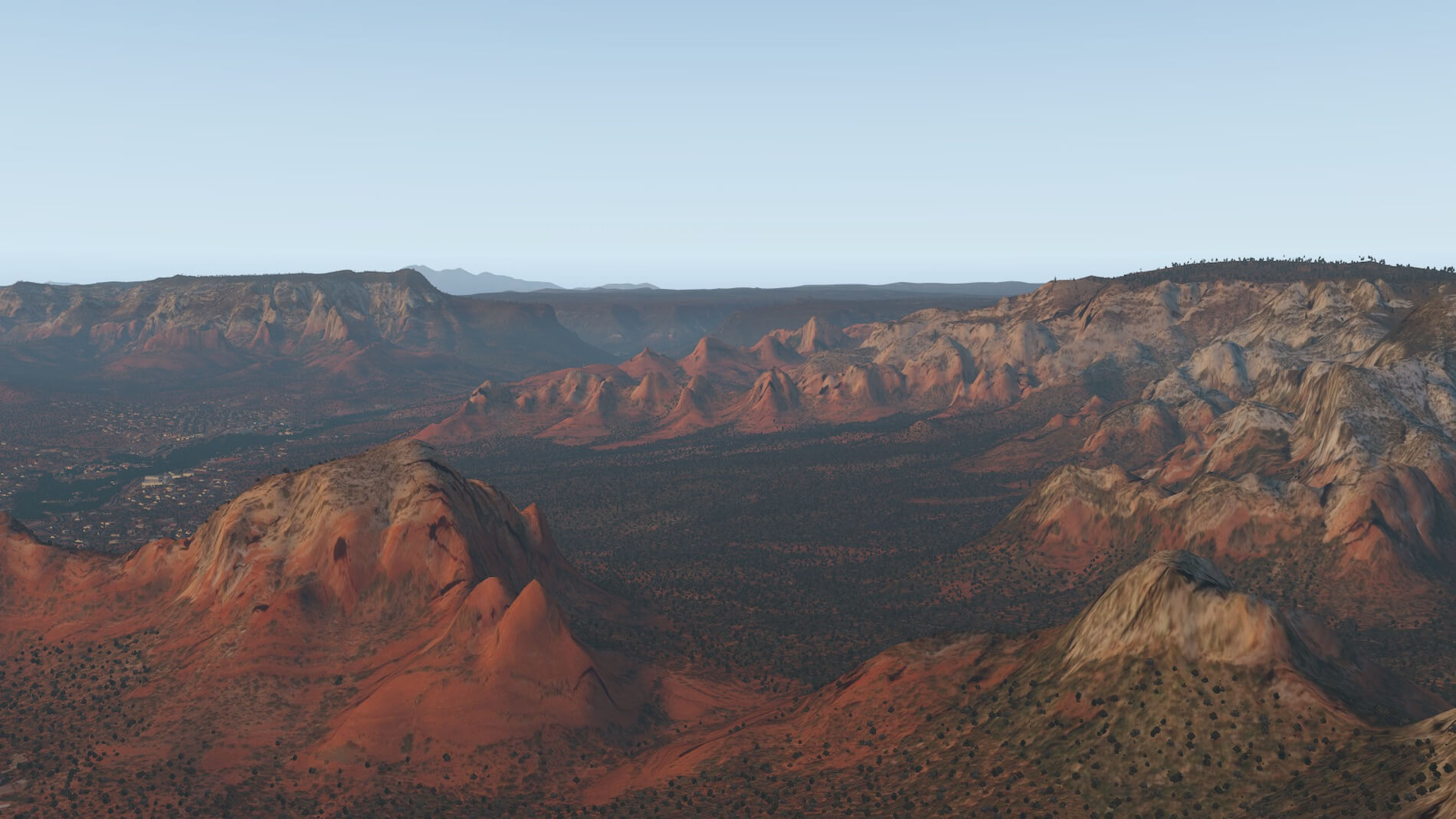
The next set of screenshots commences with a mountain range in the vicinity of the other rock features. The lighter colors of the sandstone structure in the upper half of these mountains show how the composition of the rock changes as we traverse up and down the formations. All of this rock was deposited over millennia by silt and erosion flowing into inland seas in this area, prior to the later uplift. Next an interesting shot- turning my X-Plane camera around 180 degrees I’m looking back at the airport.
You can see how it is located on a mesa (I got the airport beacon green light in shot), and to the immediate right of the airport. The hill that causes much of the challenges in arrival and departure to/from this airport- it is indeed quite an obstacle!


The next four screenshots show some of the rock features already discussed from a different perspective, and the town that X-Codr has made a great job in portraying.


Some brief shots and information on some of these rock features is available via this link. (https://www.gatewaytosedona.com/sedona-arizona-information/sedona-red-rocks-and-hiking-trails/90-sedona-famous-red-rock-formations-bell-rock-vs-cathedral-rock)
One last screenshot from X-Plane 11, this is the canyon that Oak Creek has made, and is where the road lies as you access Sedona from the north. The road winds down this canyon, having come from the top of the canyon walls, which is the edge of a relatively flat area extending through Arizona. Until you get to the rim of this canyon you are unaware of it being here.
Oak Creek Canyon is a river gorge located in northern Arizona between the cities of Flagstaff and Sedona. The canyon is often described as a smaller cousin of the Grand Canyon because of its scenic beauty.

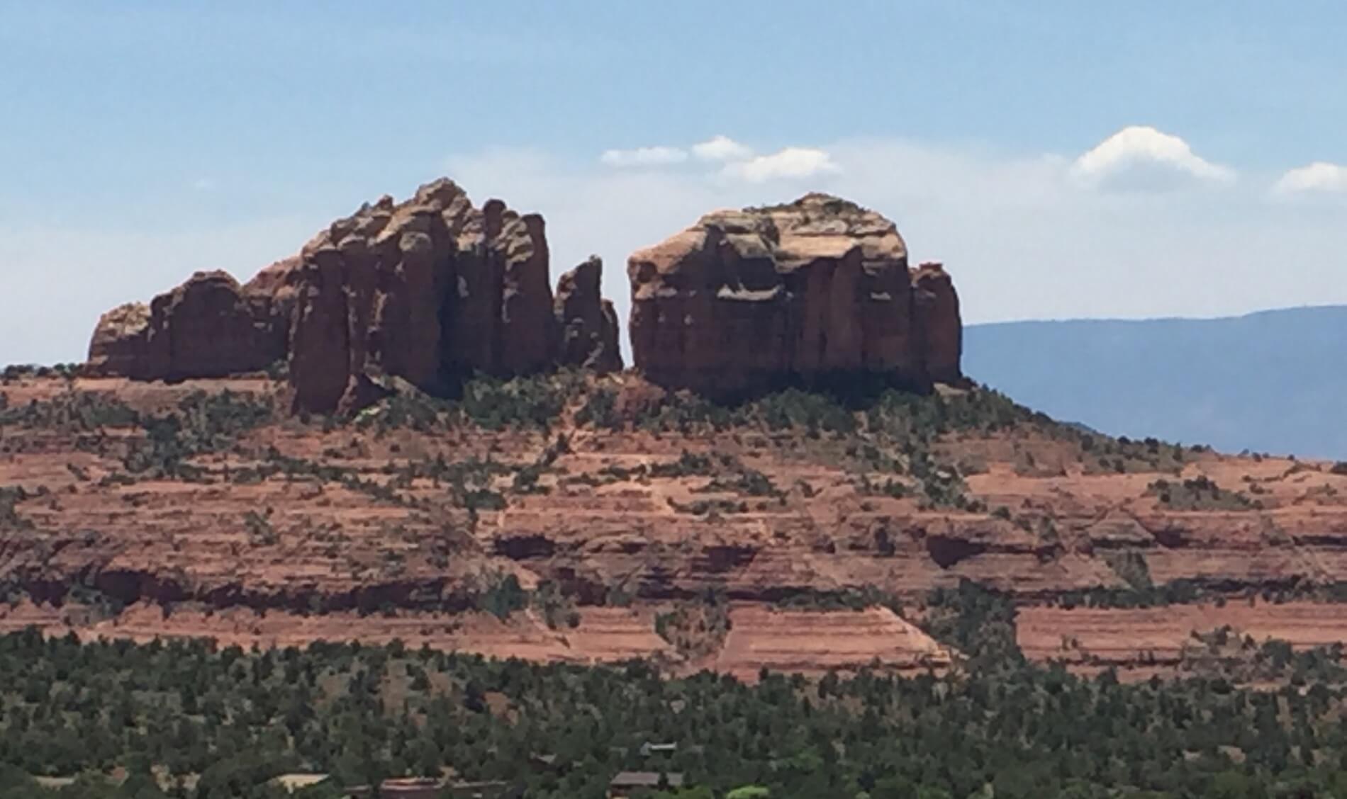
To complete this screenshot series, I am adding some real pics from my trip in 2017. All of these locations are included above from X-Codr. The first is the restaurant on the airport, the second one of the monoliths represented in the scenery, and lastly a range of mountains across from the resort (close to the airport) where we observed many color changes as the sun set.


Summary
I can’t imagine what approaching this airport to land is like- the effects of up and down drafts (as indicated in the airport documentation), the relatively short runway with its elevation, and the slope of the runway- and what it must be like to try and ignore all this amazing geology while focusing (or trying to) on landing your aircraft.!!
This wrap-up largely repeats comments made throughout the review- the rendition of the airport and surrounding landscape is very well done. That this update is free is a testament to the author, as the increased definition adds so much to the prior versions of this product.
The attention to detail is excellent, the visuals look so real compared to my actual experiences from being there. The dynamic hanger doors (there are two hangers featured) make for an excellent addition to realism.
I hope that my own photos included above will lend credibility to the immersion and faithful reproduction of the actual area. In creating this review, I kept in touch with X-Codr via PM – one item affecting graphics he brought to my attention was to set World Objects to Maximum in order to make the trees truly 3D.
I run my X-Plane on an iMac, and therefore could not make use of Sound XP plugin. My X-Plane 11.32r2 graphics settings for this review were as follows:
[table “” not found /]It has been a pleasure doing this review. I am enjoying the challenge of flying larger and faster GA aircraft into this airport, where an over-run of the runway has disastrous consequences! It’s great to see one of the truly beautiful areas in this region done so well and faithfully reproducing the main features that attract many people to this area. The scenery can be found at the dedicated X-Plane.Org Store page.
Feel free to contact me if you’ve got additional questions related to this impression. You can reach me via email Angelique.van.Campen@gmail.com or to Angelique@X-Plained.com.
With Greetings,
Bruce Knight
| Add-on: | Payware X-Codr Sedona UHD |
|---|---|
| Publisher | Developer: | X-Plane.Org | Aerosoft |
| Description: | Realistic rendition of Sedona Airport and Area |
| Software Source / Size: | Download / Approximately 3.62GB (unzipped) |
| Reviewed by: | Bruce Knight |
| Published: | April 16th 2019 |
| Hardware specifications: | - iMac late 2017 - Intel i7 4.2 GHz - AMD Radeon Pro 580 8192 MB - 32GB 2400 MHz RAM |
| Software specifications: | - Mojave (10.14.5) - X-Plane 11.40 |
0 Comments