Select Page

Vive La France with Carenado

It’s such a day as usual in the Netherlands … colder then normal or at the weather forecast they will say … it’s hotter than average. To me it feels cold, windy and whatsoever. Time to do what I promised already a while ago …. flying to France and see how the Carenado Cessna Citation flies.

It’s a long time back that I worked as ground engineer on a Citation. Not this model, but I believe one of the first 500 Series, when I’m right. It was a terrible aircraft to work at. It was small, and it had installed systems as you see in large commercial jets. Working in the cockpit was not a pleasant job, working in the tail was really a disaster. But flying the Citation 550 II from Carenado is fun.

I took virtually off from LFBD (Bordeaux–Mérignac Airport) and created with Little Navmap- one of my favorite nav planning programs – a flight plan to the Pyrenees, and then heading for the Méditerranée and finally back via Frejus to Bordeaux. The created flight plan has the X-Plane 11 “fms” format and the installed navigation equipment is the default X-Plane 11 FMS MCDU. For weather I use already for a while the FlyWithLua scripts and Environment+ lua script. I decided to go for real weather via the Laminar Research weather server.

Enjoy our exclusive screenshots!

Exclusive Screenshots “Carenado C172SP”

Flying the Grand Canyon
We’ve visited many times the US Grand Canyon National Park. Many time it was driving around by car and twice we walked down to the river and back up. Ok, not in one day, but we did it.

During one of those visits we decided to rent an airplane and fly above the Grand Canyon. No no, not what you think. I was not flying the aircraft. We paid that company for a flying trip over the Grand Canyon and for some reason, we had a lot of luck that day since we where the only 2 passengers in that aircraft. It was not a Skyhawk C172SP, but slightly bigger. Anyway, would it be great to do it once more but this time with X-Plane, an awesome photo-real scenery below and a well developed airport near the south rim.

That said, I decided to rent the Carenado C172SP Skyhawk for X-Plane 11, loaded the freeware airport of KGCN National Park airport, loaded all the ortho textures to get the best of the best down below me when flying over the canyon. How was it? Did I like it and how was the C172SP? Curious … check out the following exclusive screenshots. Enjoy!

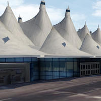
Screenshot Impression X-Codr Designs Denver

See You at Denver: Visit X-Codr Designs Denver International Airport.

Denver International Airport, locally referred to as DIA, is an international airport primarily serving metropolitan Denver, Colorado, United States as well as the greater Front Range Urban Corridor.

It’s our pleasure to show you some exclusive screenshots of Denver AirPort, modeled by X-Codr Designs. The screenshots show the bare airport with World Traffic 3 active. Further on we have no payware add-on products installed except the FlyWithLuia plugin with lua script Environment+.

That’s it and was it worth the time to spend to make these screenshots? Yes, I think so and moreover, soon X-Plained.Com will release a comprehensive review of this add-on product. more about this later. First see with your own eyes how Denver looks like during normal textures, so no other season is activated. That will come soon!

For now, enjoy our exclusive Denver screenshots.

Carenado PA31 / DO228 Adventures

Today is such a day that you can’t go out, so time to find something else to do. I had a long list of things I needed to do for X-Plained.Com. One of these “things“ to do is replacing the 2nd fullwidth slider on the front page with new aircraft screenshots. But there’s more to do like making a flight about ortho scenery in The Netherlands and about the Grand Canyon National Park with Carenado aircraft.

Your personal reporter Angelique van Campen rented the Carenado Piper PA31 and took off from a nearby airport to see the beauty of the Grand Canyon National Park, made possible by Org user Forkboy2. These photo real packages of Arizona and in particular the Grand Canyon are huge, but oh oh, so beautiful.

Oh, there’s much more. Want to see it? Then you must check out the following screenshot impressions. I would say .. enjoy our exclusive screenshots.

Forkboy2 U.S. Ortho Photo Grand Canyon

This is just a small screenshot impression of Forkboy2 ortho photo Grand Canyon HD. There’s of course much more to see, and a lot to download and a lot of time needed to convert the JPG files into DDS files.

Long story short; it was worth the time and waiting as you can see for yourself. Just to give you the right feeling; these screenshots are a combination of the packages Arizona and Arizona – Grand Canyon HD as well as the belonging overlay files.

According to Forkboy2 “This project provides high quality orthophoto scenery for X-Plane that can be easily shared among the community. For now, I’m working on the United States; however, if you know of a good WMS or Tile server containing public domain imagery from other countries, post a comment and I will take a look. Each orthophoto package will cover a large region that may include multiple states, or a portion of a large state.”

Curious how it looks like? Then check out this exclusive, on behalf of Forkboy2 screenshot Grand Canyon impression.

JustSim EBBR Impression

While busy writing for you a comprehensive review of the JustSim EBBR Brussels International Airport, I found it a good idea to make some exclusive screenshots. These screenshots should give you a good impression of how the airport looks like and how it works with World Traffic 3 or JARDesign X-Life.

Not that I know every corner at the airport by heart, the maintenance and cargo area I do. But for the rest of the airport I must say .. I’m impressed. It’s full with animated ground objects, building are modeled with great details, and so on. The frame rates are acceptable although it must be said that it depends on your rendering settings, as usual.

For now, enjoy the look and feel of JustSim EBBR!