The Almost Real EU Alps
Wow
No, not this time an “Introduction” but the “Wow” factor. Don’t worry, I’ll tell later why it got from me the “Wow” factor.
Although the ALPS UHD XP12 package from, Frank and Fabio is gorgeous, I write on purpose “almost” since the Alps out there in the EU are the real ones neither less, this X-Plane 12 package looks awesome. After I got the package from Frank Dainese and X-Plane.Org, it’s actually the product from Frank Dainese and Fabio Bellini. As the title suggests, this is their first updated package for X-Plane 12. And as you might have heard, it’s a huge package and combines many Alps areas together and therefore, it’s not actually an updated version of what it was.
The ALPS UHD XP12 covers according to Frank “a stunning 8000+ square kilometers between Italy, France and Switzerland, including four packages (Eiger Park, Matterhorn park, Aosta, Mont Blanc) besides the many other main peaks of the Alps, almost all reconstructed with detailed 3D models with photographic textures.”
Frank continues “we reproduced major cities and towns with placement of thousands of custom buildings such as churches, monuments public buildings, stations… and houses with characteristic typology of the place also as an integration of autogen. Further one, Frank and Fabio reproduced major airports and air-fields, some of them added in areas of tourist interest such as Cervinia, Gressoney, Courmayeur and Chamonix. All the terrain in this area has been reproduced with the use of polygons/textures that reproduce the area according to the terrain characteristics.”
Fabio adds to this “territories that are included are Val d’Aosta with LIMW and city, all side valleys Valtournenche, Ajas, Gressoney, Sesia, Macugnaga, Olomont, Gran S.Bernardo, Val Grisenche, Val Saverenche, Cogne, Matterhorn Park, MonBlanc, Courmayeur, Chamonix, Airfield Megeve, Sallanches MBlanc, Meribel, Courchevel, Zermatt, Zinal, Saas Fe, Eiger Park with Grindelwald, Kleine Scheidegg, LauterBrunnen, Wengen, Murren, Interlaken Airport, Thun Airport, Meiringen Aiport, Reichenback airport, Raron Airport, Raron Air Zermatt, Raron Gampel.”
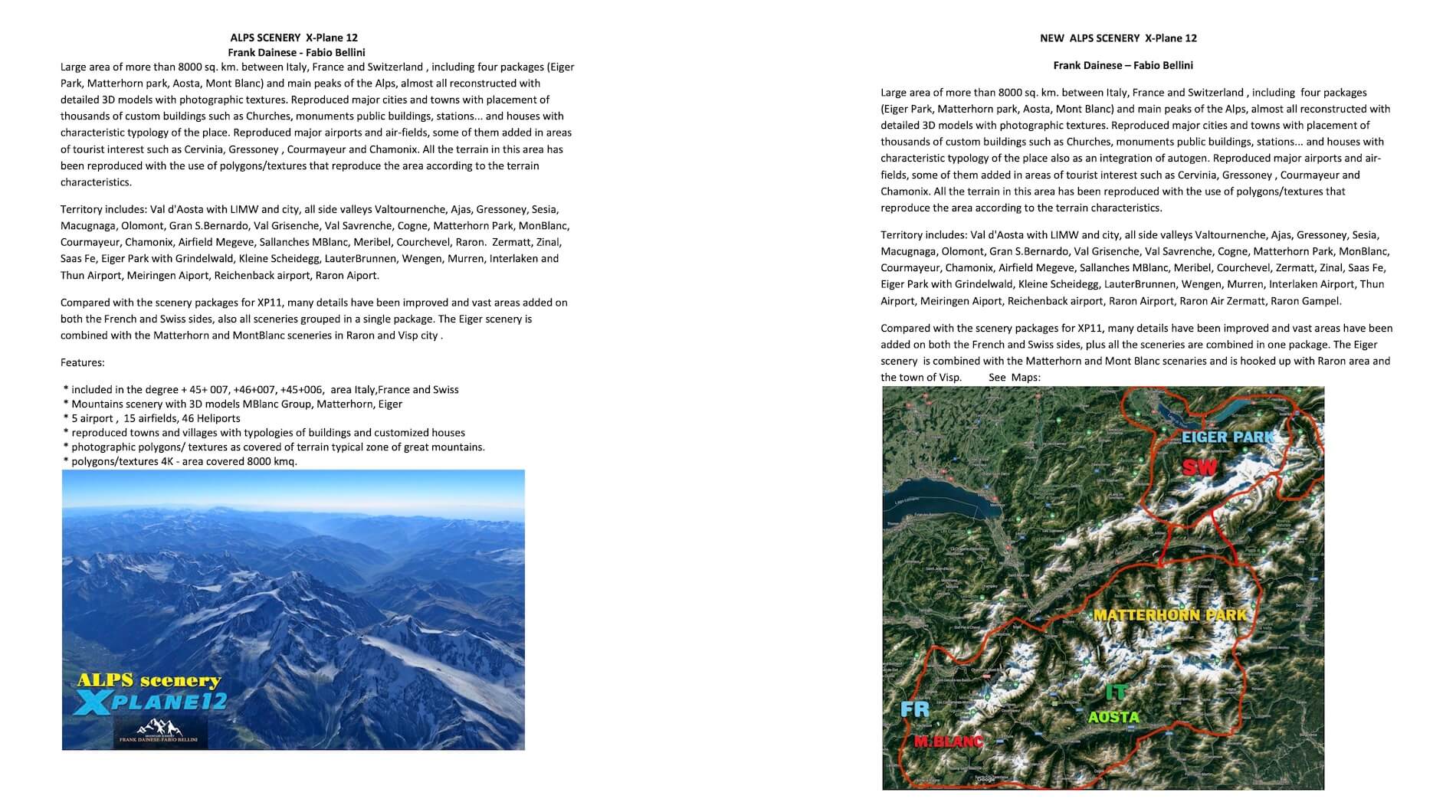
For those who aren’t aware of their work; Frank and Fabio are known of their 3D parks packages for X-Plane 11 like the 3D Everest Park, Cerro Torre Los Glaciares 3D National Park, Dolomites 3D, and one of their latest XP11 package, the Banff National Park UHD. Frank and Fabio continue with “compared with the scenery packages for XP11, many details have been improved and vast areas have been added on both the French and Swiss sides, plus all the scenery are combined in one package. The Eiger scenery is combined with the Matterhorn and Mont Blanc scenery and is hooked up with Raron area and the town of Visp.”
That said, it’s almost impossible for me to cover every tiny detail that is added in this ALPS UHD XP12, but I will give it a try.
Installation and Layout
Some simmers don’t like these sections since they don’t tell you anything about the product itself, but for others it’s useful information in case they struggle with the right order in the scenery_pack.ini file. Therefore, worth to highlight this section.
The installation is easy and straight forward, but you need preferable a fast Internet connection since the overall package is 3.35Gb and unzipped is a massive 9.58Gb. It’s simple, unzip the Alps UHD XP12 file, and end up with the same named folder but with a lot of sub folders. Next you copy and paste all those sub folders into the X-Plane 12 Custom Scenery folder. Since I’m on a Mac, I don’t have a program like XOrganizer, so for all Mac simmers I suggest that you rename the scenery_pack.ini file (or you delete it) and let X-Plane create a new scenery_pack.ini file at startup. It will place all the individual folder at the right position in the scenery_pack.ini file in an alphabetic order.
A quick look to the layout of the folders. The following screenshot shows you the overall list of included ALPS UHD XP12 folders. Many folders start with “3D” which means when the scenery_pack.ini file is created, they stay at the top of the ini file according to alphabetic numbering. The same for all others. In this screenshot you can also spot the included or modeled airports like for example LIMW (Aosta Valley Airport – Italy), LFHM (Megève Altiport – France), Courchevel Altiport (LFLJ – France), Altiport de Méribel (LFKX – France), Aérodrome de Sallanches Mont-Blanc (LFHZ – France).
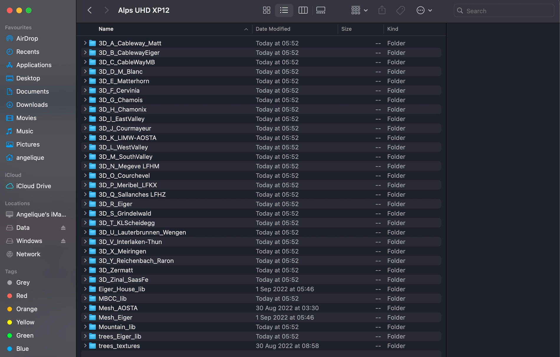
As you can see on the screenshot, the package comes with folders dedicated to unique 3D trees, and its own mesh for specific areas. Talking about own mesh. It also means that the ALPS UHD XP12 package is not compatible with Orbx Courchevel Altiport. According to Frank this is due to a different mesh. And then also this; I’m not 100 percent sure but worth to mention it. I own Orbx “Global Forests v2” and I’m not sure if it’s compatible with ALPS UHD XP12 and therefore I disabled the command line in the scenery_pack.ini. For your information; you can disable a line in the scenery_pack.ini by adding _DISABLED to it thus the specific line should look like SCENERY_PACK_DISABLED.
And finally is there any documentation included? Although I got the package at the end via Frank and X-Plane.Org, I couldn’t spot a document, but via this dedicated Frank Dainese Mountain Scenery Org link you can find some additional information although not a map or whatsoever, but I guess work is in progress.
Quick Comparison
From the start I had the idea to review this scenery package although I knew that it won’t be an easy task to cover over 8000 square kilometers (roughly 3000 square miles) and/or to figure out how much it differs with the X-Plane 12 default Alps area. In general, the default X-Plane 12 Alps are modeled with mesh, ground textures, trees, some airports, airfields or helipads as well as other autogen objects like buildings, houses and whatever more can be found in this area. But is it all enough?
When I hover above the default X-Plane 12 Alps from a certain altitude , you could get the impression that it doesn’t look that bad, but when you know “where to look for” then you will be surprised to see that many things in the default scenery are completely missing, trees are placed at positions they don’t belong or the trees you see can’t be found in the Alps.
This is then only about trees but what do you think about the typical houses that can be found in this region, in particular the Swiss chalets. So there’s much more that makes the huge difference between the ALPS UHD XP12 and the default X-Plane 12 scenery. And what do you think of the airfields and helipads that are missing or when an airfield is included in the default scenery, then there are no buildings at all and so on. Time to explore. Time to check out some differences or comparisons.
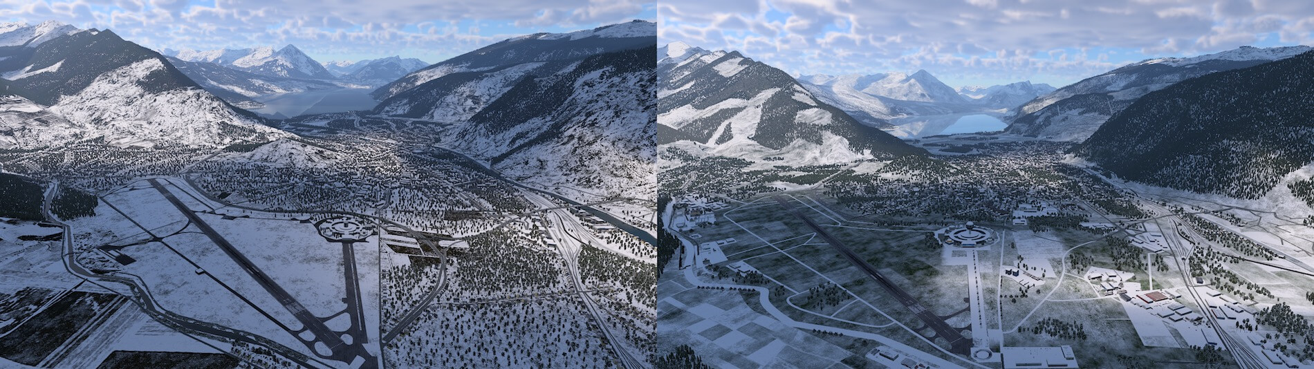
Sallanches Airport (LFHZ) Eastern direction Mont Blanc Massive
Lets go for our first comparison. On the left side you see the default X-Plane 12 scenery while on the right hand side the ALPS UHD XP12.

At first you could think that there’s not much difference between this screenshot compilation – again …. on the left the default X-Plane 12 scenery with on the right the ALPS UHD XP12 look – but a closer look tells me that there are many differences visible, typical by the way for all mountain areas.
First of all, the screenshots are taken near the airport of Sallanches (LFHZ) looking in a eastern direction to the Mont Blanc massive. On the ALPS UHD XP12 you and I can see that the trees or forests are placed where they should be, lakes or rivers have realistic shapes, and since it’s Winter, rivers are frozen and covered with snow which is in most cases with the default scenery not the case. Then the “shape” or the mesh of the Mont Blanc massive looks as real as it should be. Again, this is not the case on the default scenery. Then another clearly visible difference is the different integration of the ground textures with forests, rocks, farmland or grass areas. Either on the default scenery it’s wrong or too blocky while on the ALPS UHD XP12 it looks realistic as it is in real. Last but not least is the presence of more airfields or helipads that are integrated and included in the ALPS UHD XP12 package. On to the next comparison, the Zermatt with Matterhorn mountain.
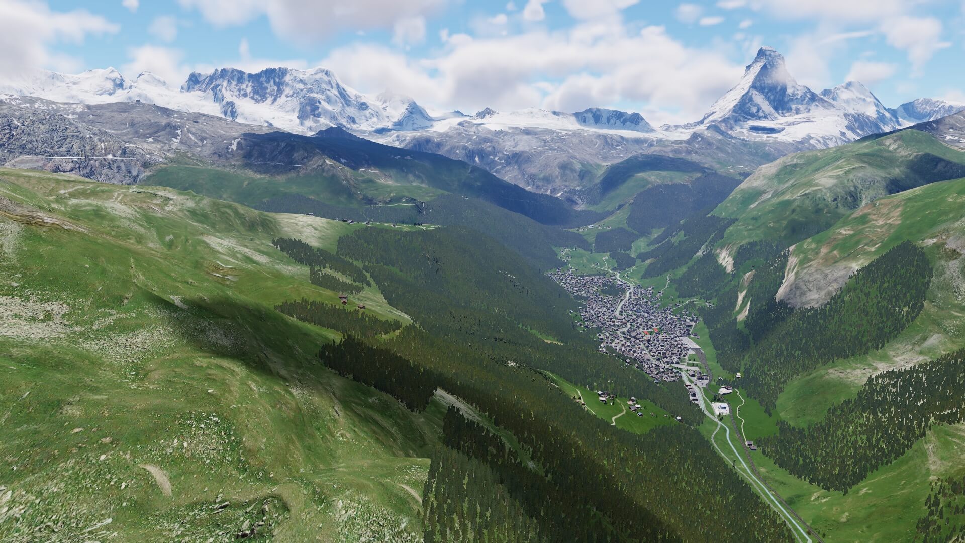
Zermatt with the Matterhorn
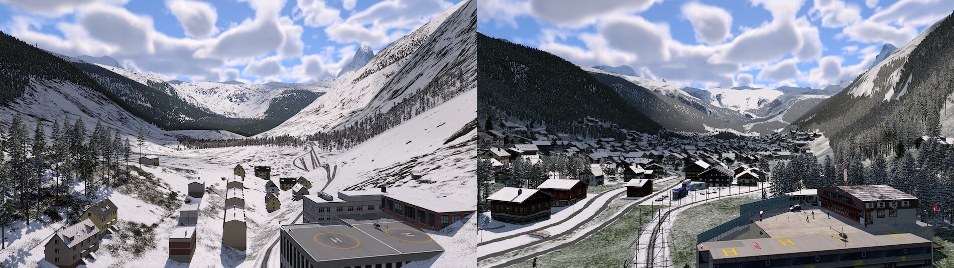
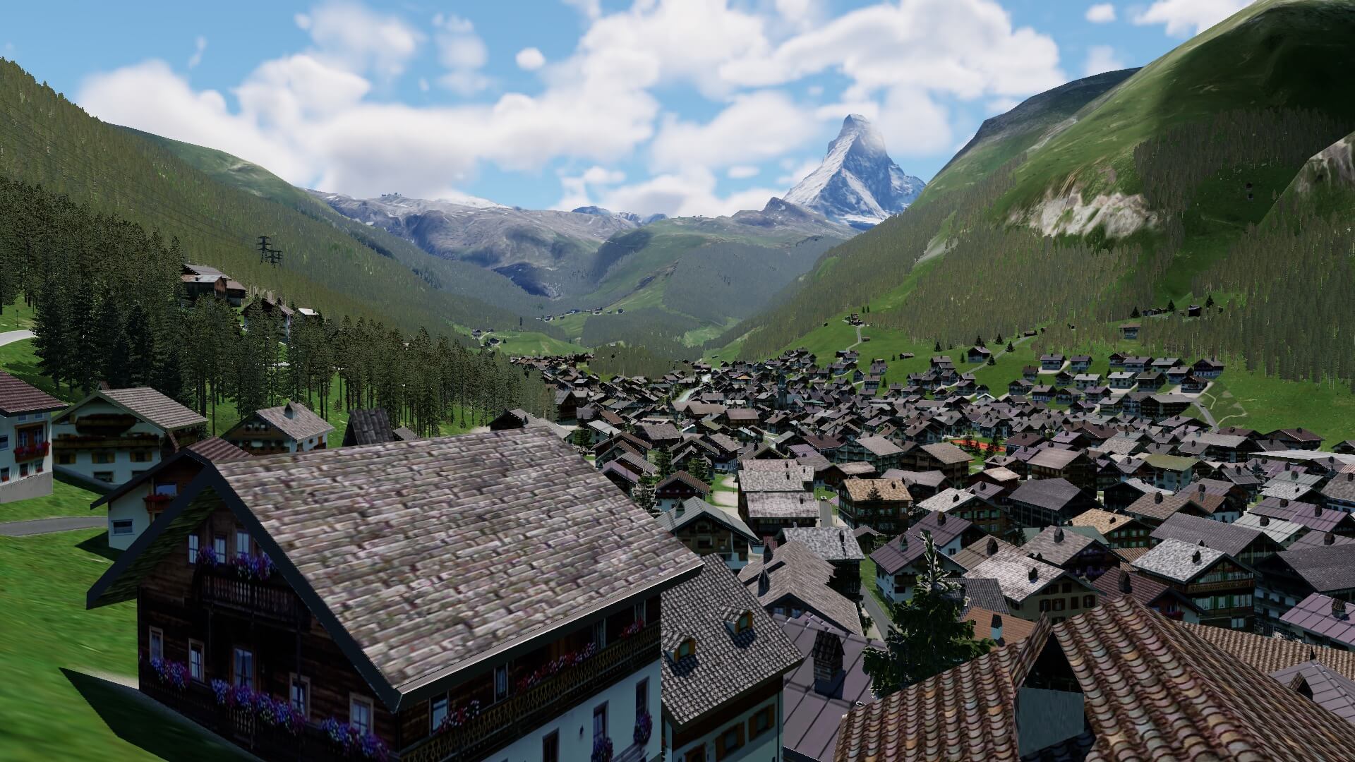
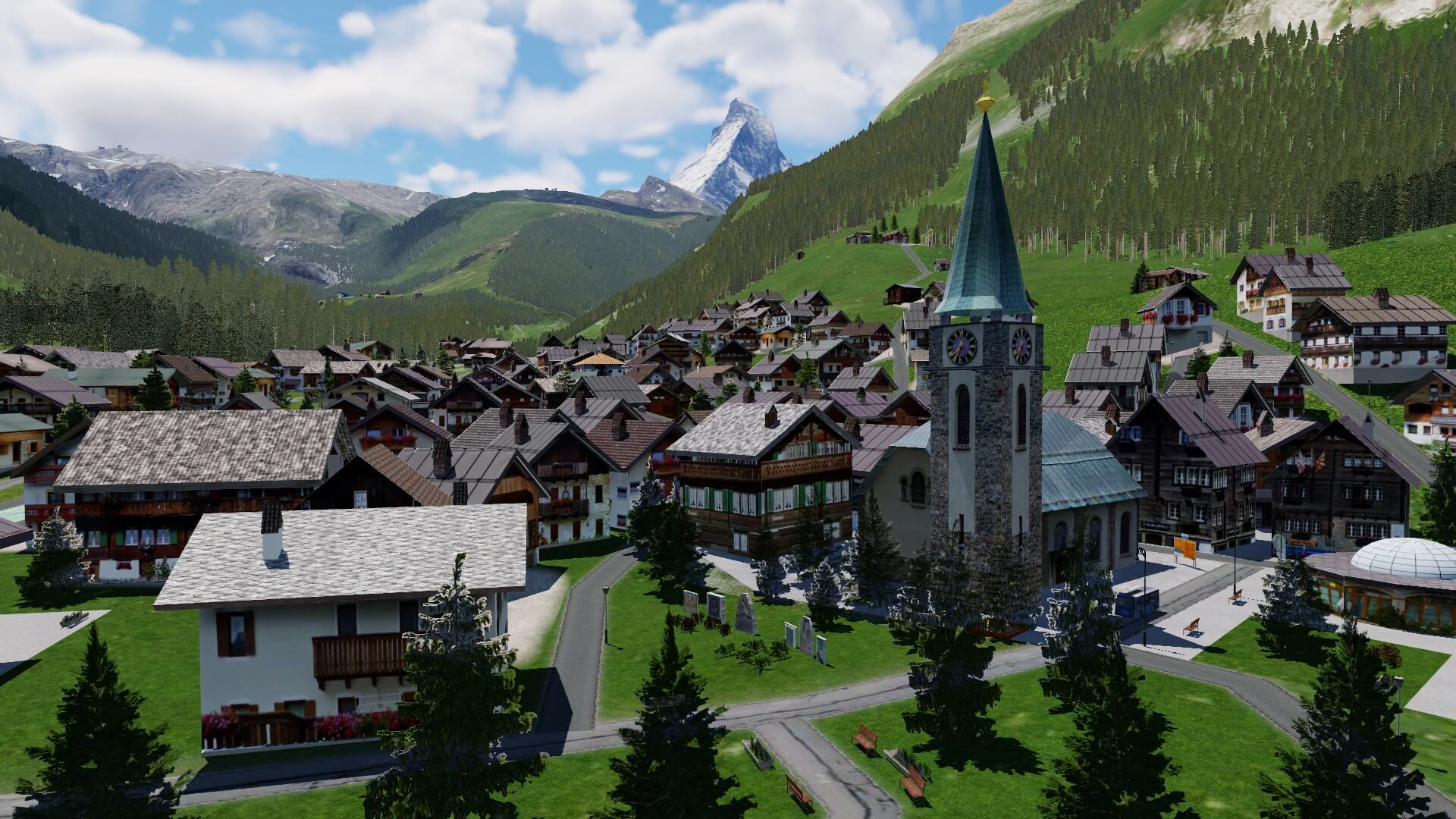
Ok, lets go to another famous example …. Zermatt with the Matterhorn. I know, this is one of my favorites and for sure those who like the European Alps too or our Swiss simmers. The small and cosy city of Zermatt is with a lot of love and eyes for many tiny details modeled in the ALPS UHD XP12 package by Frank and Fabio. What you see in the default X-Plane 12 scenery .. forget that!
Hold on.
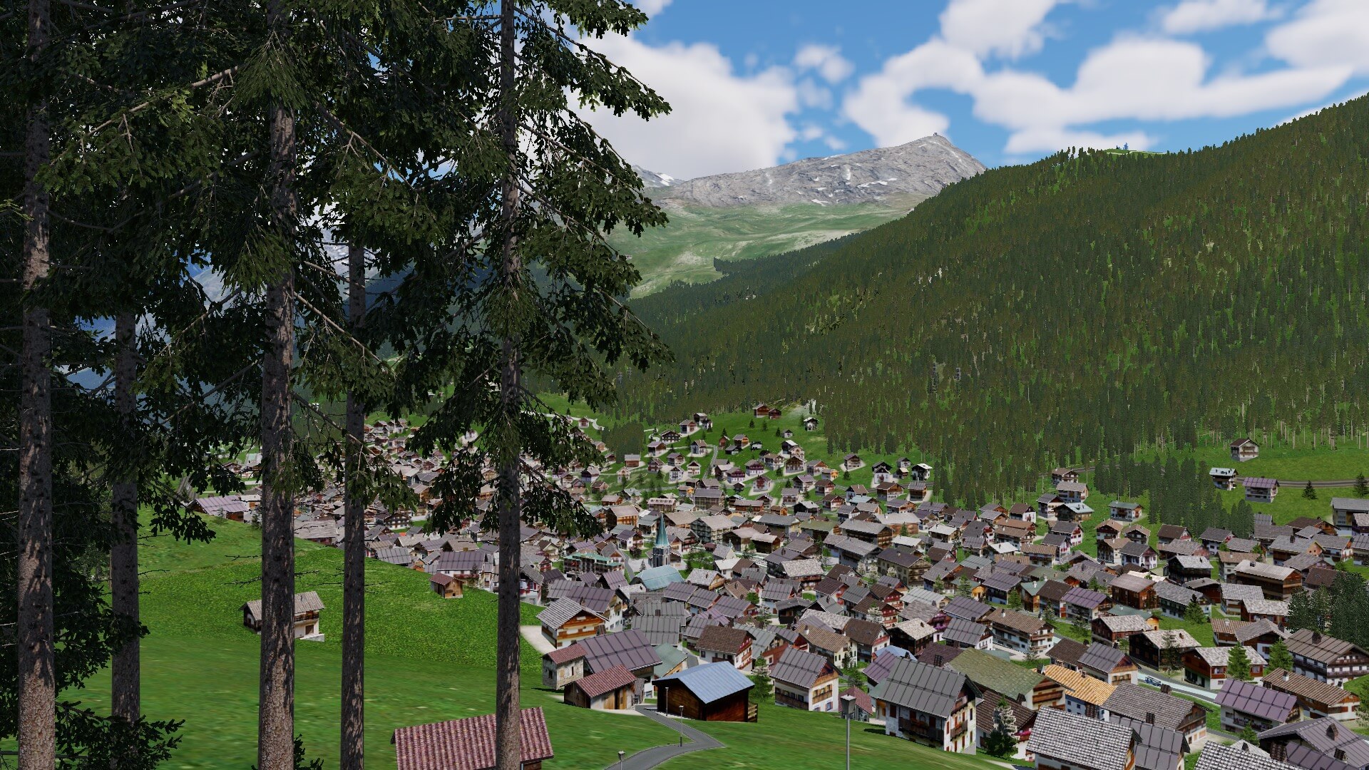
It’s not only that the city of Zermatt which is well modeled, back in the valley you’ll find other villages that are well modeled too like Täsch which is a municipality in the district of Visp in the canton of Valais in Switzerland. It is located about 5 km north of Zermatt. We can go even further back into the valley. Also modeled with the typical Swiss houses are the villages Randa and Bergfreund and that’s it till here. Interesting to see is the modeled Matterhorn Terminal Täsch since driving with your car any further to Zermatt isn’t allowed. One last remark before I continue with the city of Zermatt and the almost famous Matterhorn is this. The screenshots show you a beautiful white winter landscape, but lets be honest, during Summer it’s green, fresh green grass, beautiful green hills, whenever applicable trees with green leaves or pine trees and so on except that the Matterhorn itself and surrounding high peaks are partly or completely covered by snow.
Anyway, let’s go back to Zermatt, but first a quick look to Zermatt and the Matterhorn.


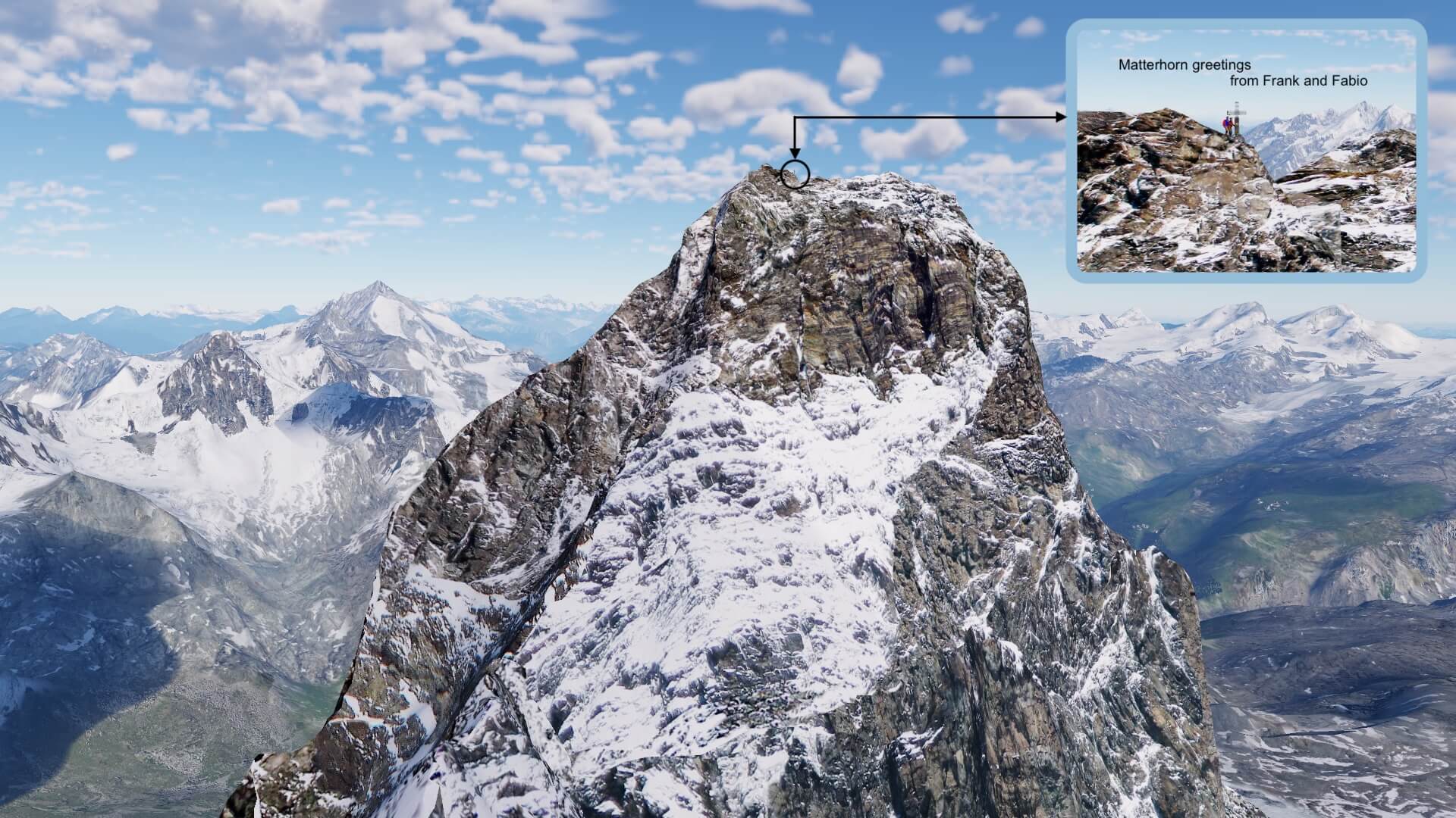
The Matterhorn was my first famous mountain or if you wish my first encounter with ALPS UHD XP12 and I can tell you, it had and still has the full 100 percent WOW factor. My goodness, not only a gorgeous look, but on the second screenshot you see an insert of the real Matterhorn and oh my goodness, this really looks smashing. It is indeed an almost perfect replica of the real Matterhorn. I write on purpose “almost” since there’s only ONE Matterhorn and that’s the real one. Anyway, the three close-up Matterhorn screenshots are really a pleasure to fly around in this area. The best would be with a helicopter, but to fly it properly, you need special hardware for it, but an ultra lite aircraft would be also possible.
Although I didn’t made yet any close-up screenshots of the area and village of Zermatt, I can tell you already that it looks gorgeous. Of course, not every typical Swiss house has razor sharp textures, but Zermatt and all the other villages included in this package are modeled and replacing the default X-Plane houses which has nothing to do with Switzerland. A couple of screenshots from the village of Zermatt? Right on, here you are.

And now, via Bern we drive in a SouthEast direction to the airport of Interlaken.
Interlaken and the Eiger
Time to explore another interesting part of Switzerland; Interlaken with southeast the Eiger and a bit further the Jungfrau with the Jungfraujoch. For those who aren’t familiar with the city of Interlaken; Interlaken is a traditional resort town in the mountainous Bernese Oberland region of central Switzerland. Built on a narrow stretch of valley, between the emerald-colored waters of Lake Thun and Lake Brienz, it has old timber houses and parkland on either side of the Aare River. Its surrounding mountains, with dense forests, alpine meadows and glaciers, has numerous hiking and skiing trails.
The following screenshot shows the airport from Interlaken (LSMI), the JungfrauPark Interlaken which is actually a children’s amusement center, but theres’ so much more to see on this comparison screenshot. Again, on the right side the ALPS UHD XP12 package. You can clearly see that the ground textures, rivers, lake, village, houses, buildings, trees, forests, it’s all very accurate while on the default X-Plane 12 lots of things are missing or completely incorrect. Not that I blame X-Plane.Com since this is something that can be expected, but therefore we have Frank and Fabio who make it for you.
Hold on, there’s another surprise I have for you; when we look in a southeast direction. I hover up up and even further up into the sky, I see from a far distance the famous Eiger, but to what mountains range does the Eiger belong? Yeah, there are so many high peaks in this area, that before you know, you’re lost.
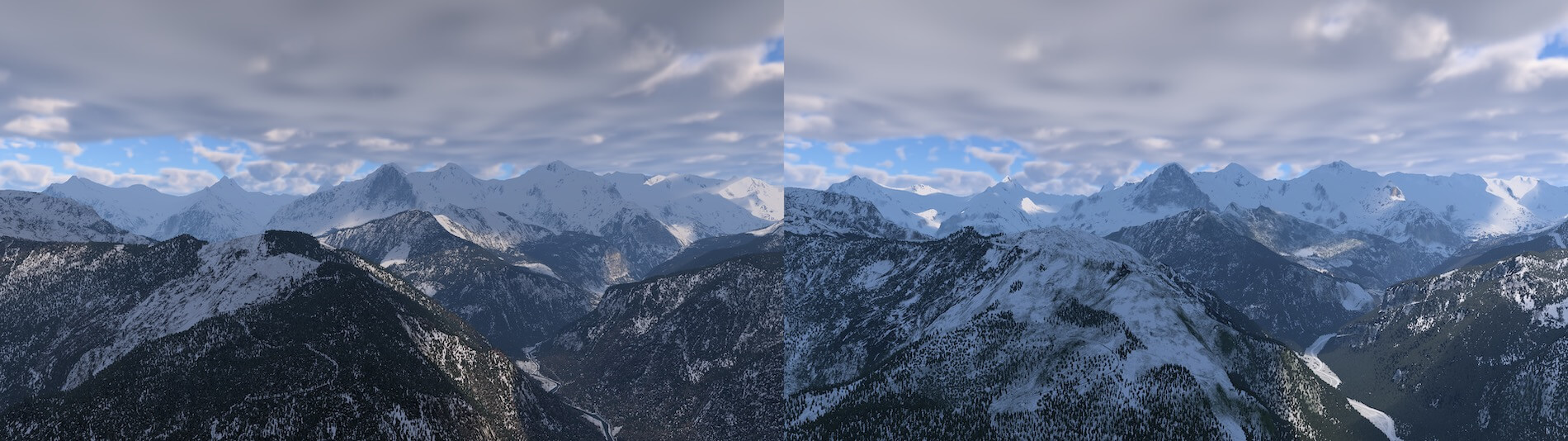
The previous screenshot is again one of the many I made before and also seen during the Mont blanc Massive. When you quickly look to the overview, you could think that there’s not so much difference between the default and ALPS UHD screenshots, but the reality is that the ALPS UHD XP12 offers a lot more, a lot more refinements like the frozen river during the Winter period, the textures, trees or forests on the hills, the correct representation of the mountains itself and of course the mesh.
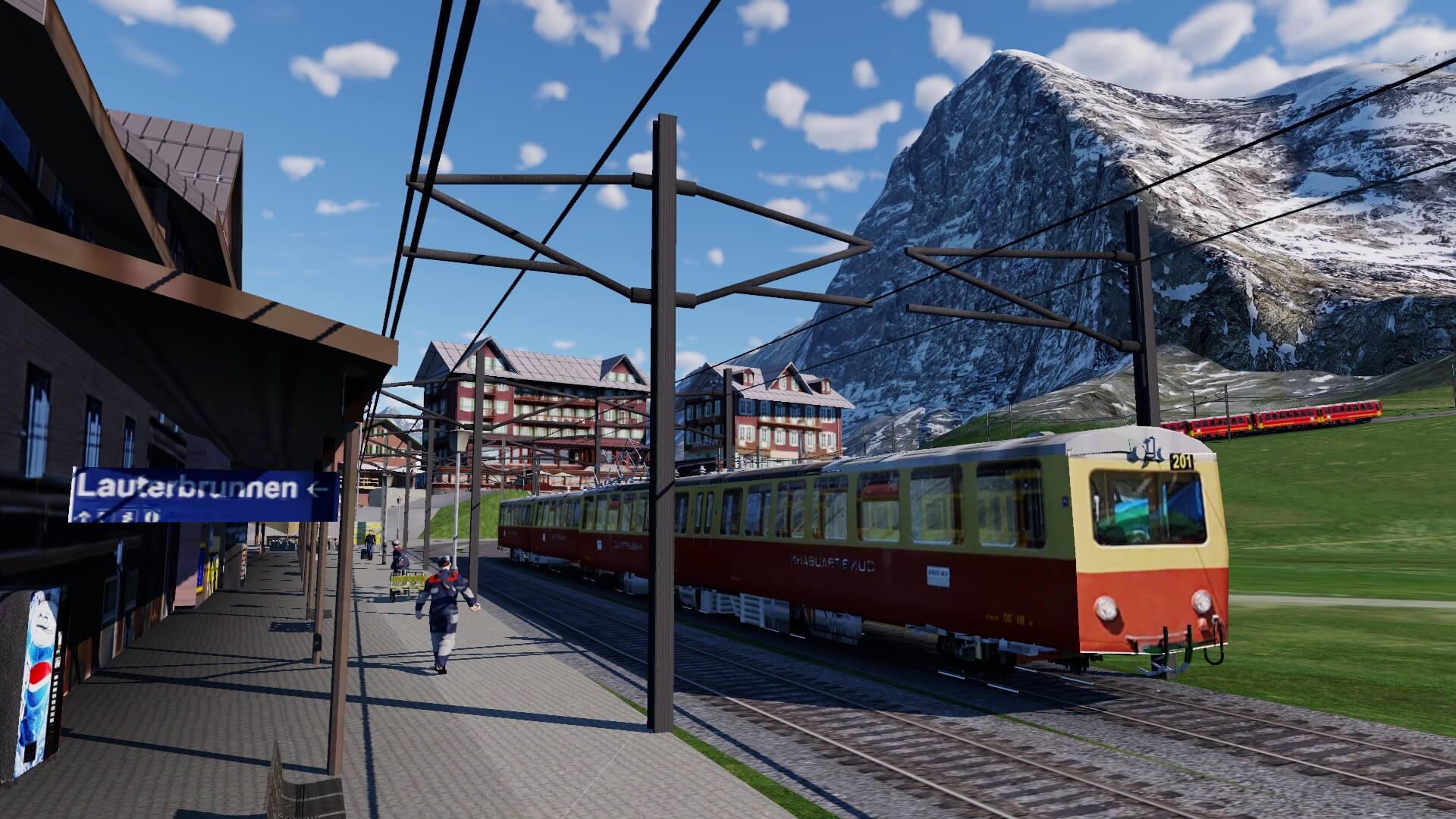
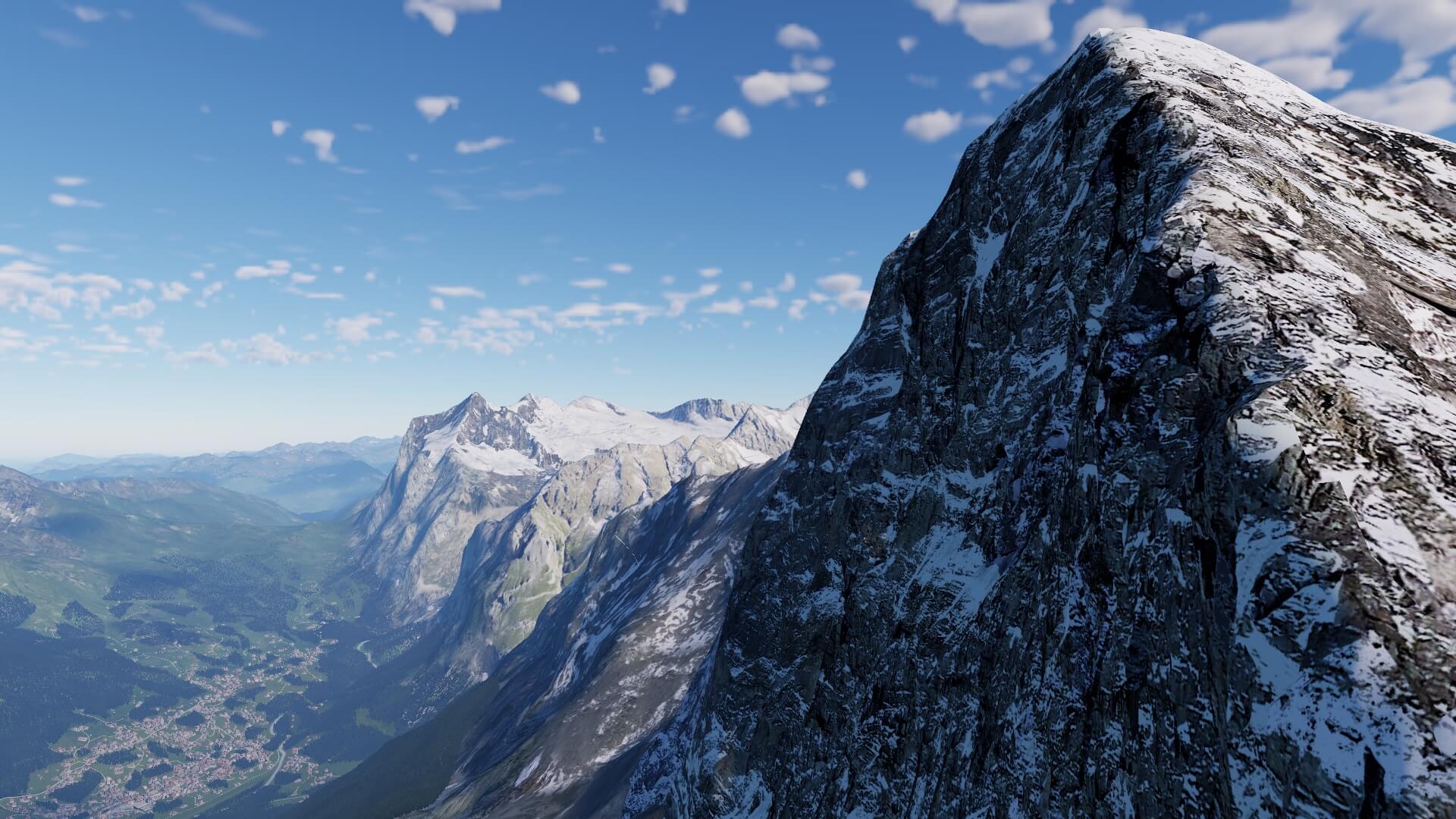
But let’s check out the Eiger ….. the Eiger is a 3,967-metre mountain of the Bernese Alps, overlooking Grindelwald and Lauterbrunnen in the Bernese Oberland of Switzerland, just north of the main watershed and border with Valais. It is the easternmost peak of a ridge crest that extends across the Mönch to the Jungfrau at 4,158 m, constituting one of the most emblematic sights of the Swiss Alps.
Ok, got it?
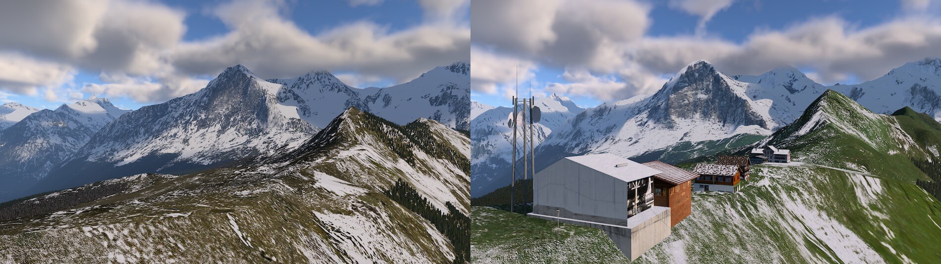
Nearby the Eiger as can be seen on the default scenery it offers nothing on the plateau however, in reality you can ski here and therefore you find buildings, elevators, a hotel with restaurant, a train station or other typical objects that belong to this area. These tiny, no, huge modifications can be found in the ALPS UHD XP12 package and I can tell you, not only here nearby the Eiger it’s well done, but on many many other places in the package too. Anyway, the following screenshots show you such a typical area and of course with the Eiger itself. The default X-Plane 12 Eiger doesn’t look that bad compared for example with the Matterhorn, but when you look in more detail to the ALPS UHD XP12 Eiger then you understand why you should buy this package.

Aosta Valley Airport (LIMW)
And my last quick impression is the Aosta Valley Airport. It lies in Italy, at the other side of the Mont Blanc Alps massive. Actually, when you drive from Chamonix (France) via the Mont Blanc tunnel to Italy via the A5 / E25 you reach the city of Aosta and pass along LIMW. Why do I highlight Aosta Valley Airport? This is one of the dedicated modeled X-Plane 12 airports included in the ALPS UHD XP12 package. It’s not a small airport since the largest aircraft that has operated at the airport was a BAe 146 operated by Malmo Aviation, but the Boeing 737 and Airbus A318 could possibly also land there too (Source Wikipedia).
Anyway, the default X-Plane 12 does have LIMW modeled but as expected, this is far from the reality while the modeled LIMW by Frank and Fabio is as real as it gets and yes, it’s not a complex airport neither less, they did a great job. Check it out on the next screenshot. Small insert image – Copyright from AirTeamImages.Com.

90
It may be a short paragraph regarding the modeled LIMW, but that doesn’t mean the airport is not worth a further look. No, it’s is worth to check it out a bit more in depth. The large apron with the control tower and nearby hangars are in my humble opinion well modeled. It reflects the real Aosta airport, so nothing wrong with that. Ok, some will say that it’s not the most or highly detailed airport, but hold on, this LIMW and many others are included in this massive 8000 km2 Alps region. All those modeled airports are actually for free included. Keeping that in mind, you get a lot of awesome Alps scenery for such a little price!
Back to LIMW and the surrounding area.
The aprons are filled with many types of static ground equipment ranging from tractors, containers, glider trailers, stairs, fuel trucks and many other objects. It also has at several places static aircraft and perhaps the ground textures are not fully photoreal ground textures, but I’m not 100 percent sure about that. These ground textures of the grass area are definitely different then the ones in the default X-Plane 12 LIMW scenery.
The airport lies along the highway and then of course you will find the industrial area, the city of Aosta itself, so overall a busy environment. I can’t judge if every house or building is as it is in real, I do know that compared to the default X-Plane 12 Aosta area it’s a pleasure to see how it is all made. And for those who know this … I followed the main road to the Italian side of the Mont Blanc tunnel or in Italian Monte Bianco and also found the other side of the tunnel in France.
Curious how it looks like? Check out the following – again – comparison screenshot. Not many words are needed to see the huge difference between LIMW, the surrounding area and far away the mountains with the Mont Blanc massive. Even the look and feel of the ALPS UHD XP12 mountains are so realistic that that is already worth your money.

Concealed Workpieces
That’s an interesting title. Oh whatever, but believe me, you will be impressed by what Frank and Fabio all included for objects which aren’t always easy visible nor visible from the ground. Right on, lets check out those almost hidden objects.
Skyway Monte Bianco
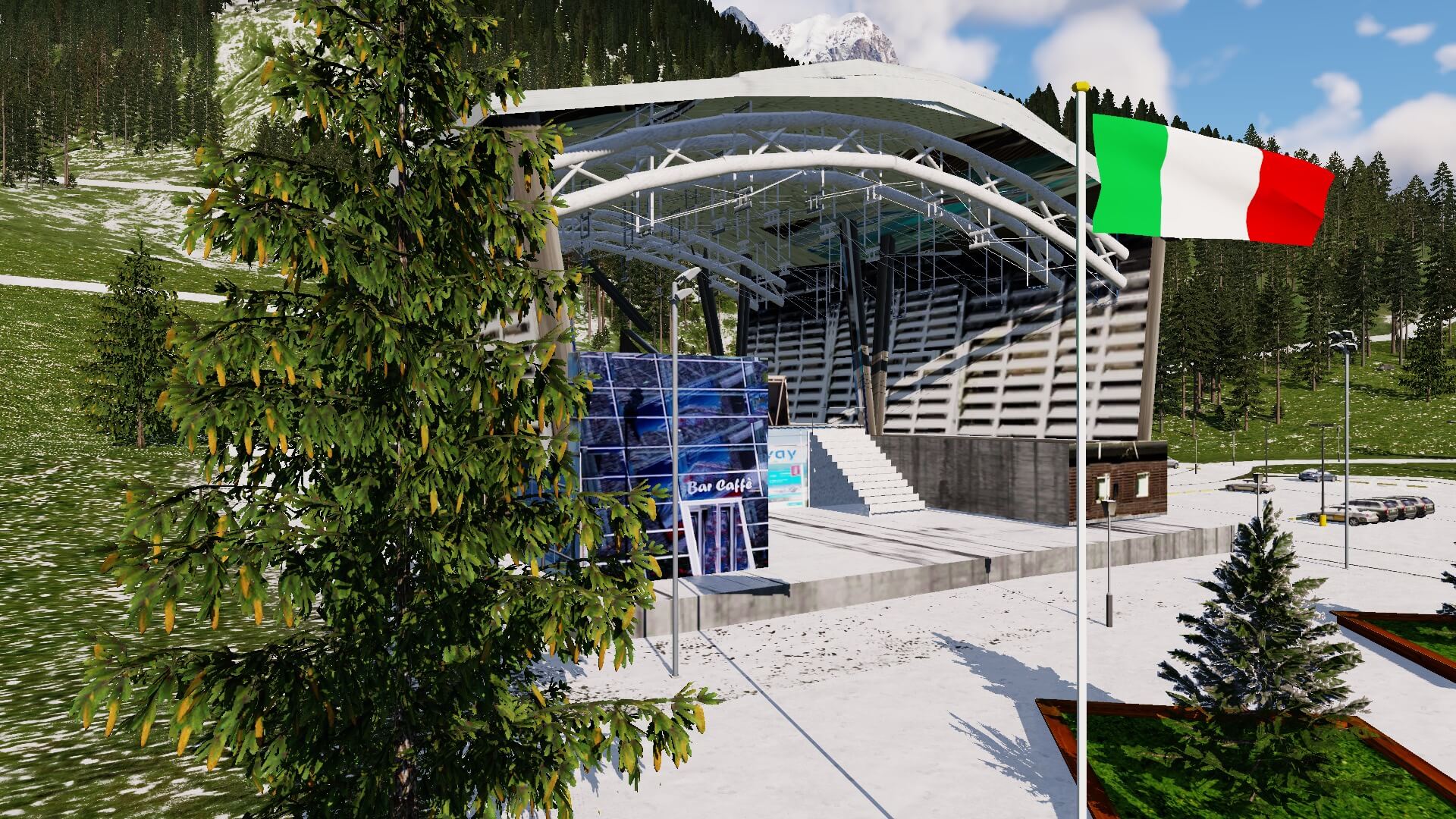
While being at Aosta Valley Airport, I take the car towards the Italian side of the Mont Blanc tunnel. Then I jump into the cable car from the Monte Bianco Skyway. By the way; Skyway Monte Bianco is a technological and engineering marvel, a feat of which Italy can be proud. It came about from a vision that was unique and futuristic compared to the traditional conception of projects of this type: the goal, indeed, was not simply to rebuild a cableway, but to create a comprehensive experience of vertical ascent.
The system was inaugurated in 2015 and today includes 3 stations: Courmayeur/The Valley (1,300 m), Pavillon/The Mountain (2,173 m) and Punta Helbronner/The Sky (3,466 m).
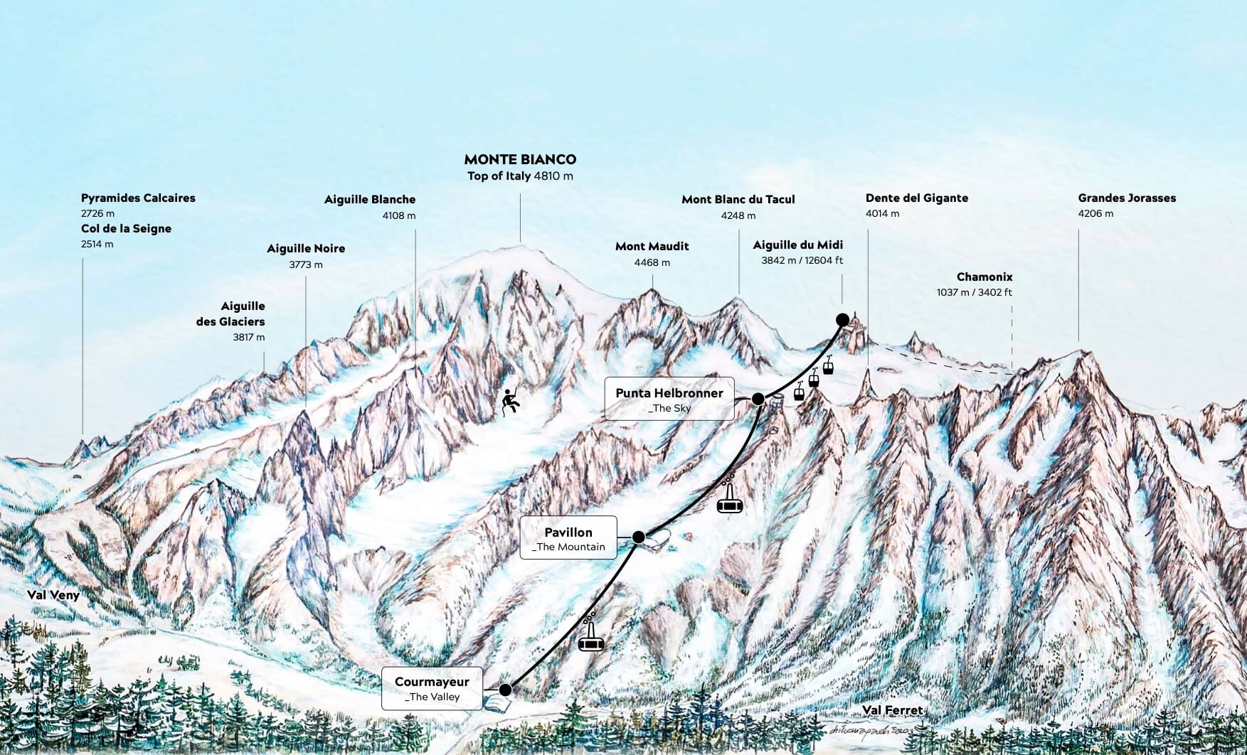
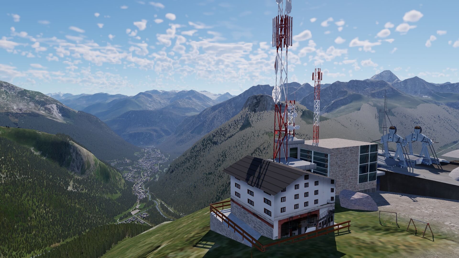
The Skyway cable car could bring you, but not sure if it is possible at the moment, to the French Aiguille du midi. Either the Italian Punta Helbronner or the French Aiguille du midi gives you in real a stunning view of the surrounding mountains as well as the Mont Blanc itself, but this is also in the modeled masterpiece from Frank and Fabio. Now it’s time to take the cable car from Courmayeur up to the Punta Helbronner and although it seems in real that the connection to the French Aiguille du midi is closed, we continue with the cable car to the French side and oh oh, this makes me sooooo happy.
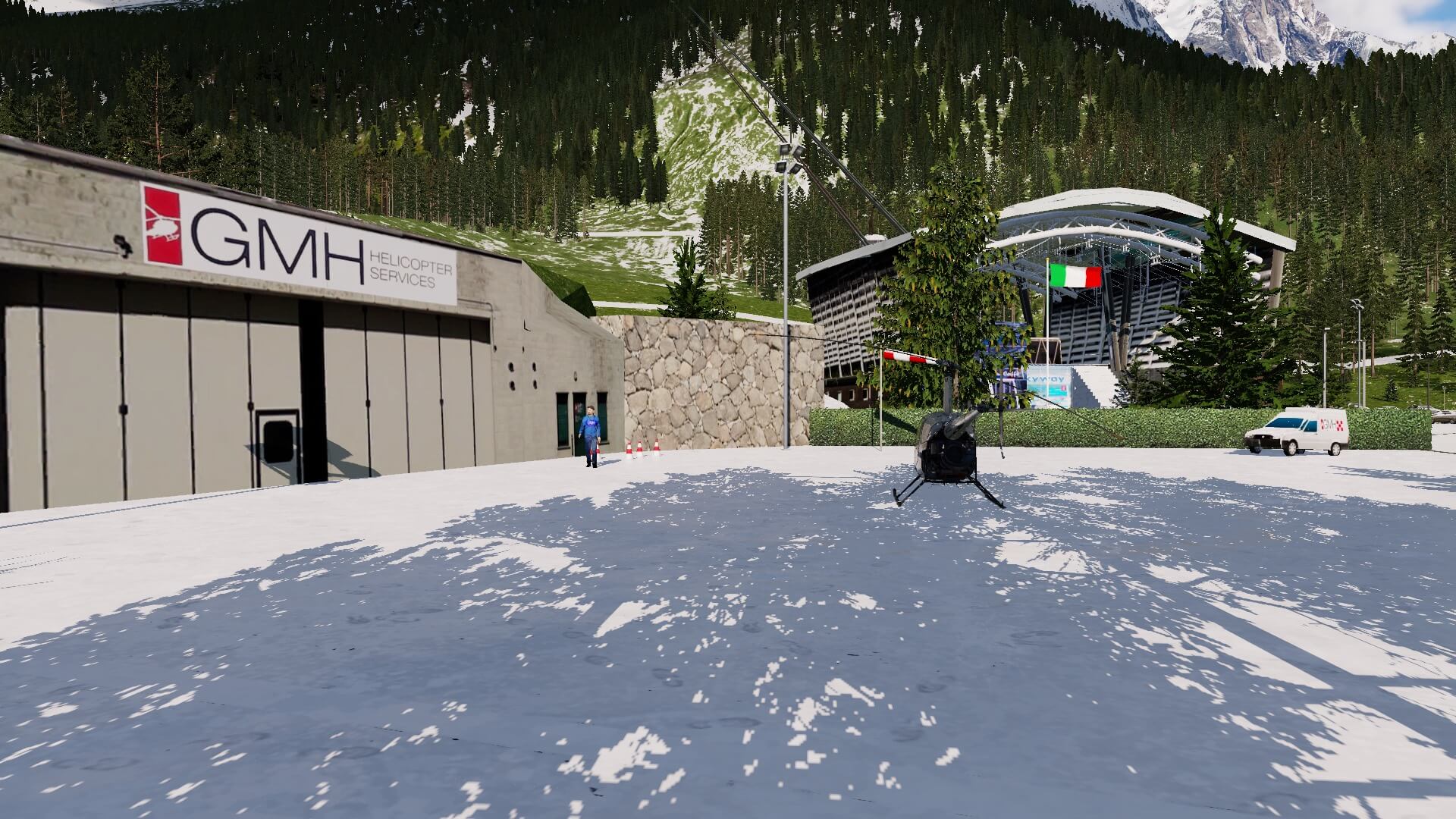
Or, you take a helicopter and start your flight from LICY, known as Courmayeur helipad just at the entrance of the Skyway Monte Bianco. Not bad, not bad at all. Besides that we go up with the Skyway, you also have a view of what is modeled down here. And although LICY isn’t modeled with all tiny details, it is there and not bad at all.
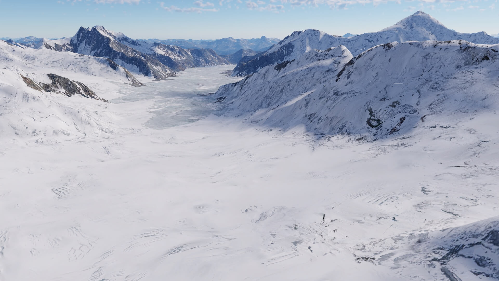
Good, we start our cable car ride from the ground station and go up to the highest point of the Italian Skyway. What said before, there’s a connection from the Italian side to the French side, and yes, it is all modeled. That the real connection isn’t always open has for the moment nothing to do with our sky trip and I can tell you, the Mont Blanc massive with all the mountains around me looks awesome. Perhaps you’re more interested in how the mountains are modeled and less in the cable car stations, but please, check out the following screenshots.


It’s almost impossible for me to show you everything I’ve seen on top of the Mont Blanc massive, but I’ll try to offer you a small collection that expresses these mountains in great detail. This time no need anymore to compare it with how it could be in the default X-Plane 12 French and Italian Alps. For those who are a bit confused. Keep in mind that the Mont Blanc or Monte Bianco lies in France while another part of the Mont Blanc massive lies in Italy. Other interesting mountain peeks which are parts of the ALPS UHD XP12, are in Switzerland but that’s for later.
Ok, back to my cable car trip. Worth to check out the following screenshots.


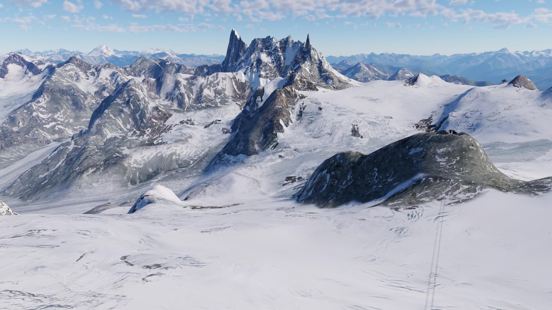


It’s stunning. It’s gorgeous. It’s really awesome. Ok, enough about those words, but what stays is that it has an unbelievable “wow” factor. It’s not only the realistic look of the mountains or the glaciers. It’s also the cable car stations, if applicable the hotels and or restaurants or even a playground or whatever you see at each station. And this is not only for the Italian Skyway, this is the same for the cable car at the French side and then in particular the Aiguille du midi. In real the Aiguille du midi station is already impressive, but that’s the same for the modeled Aiguille du midi station. In real it lies on a rock, which is of course the same in the modeled version but Frank and Fabio have to deal with the mesh and shape of the rocks. Not an easy job, but the result is gorgeous.
I mentioned it already before, it’s impossible for me to show you everything that’s included in the package, but I want to explore once more part of the Swiss mountain range with the Eiger and Jungfrau. Are you ready to join me on my Swiss trip?
Eiger, Jungfrau, Jungfraujoch and more
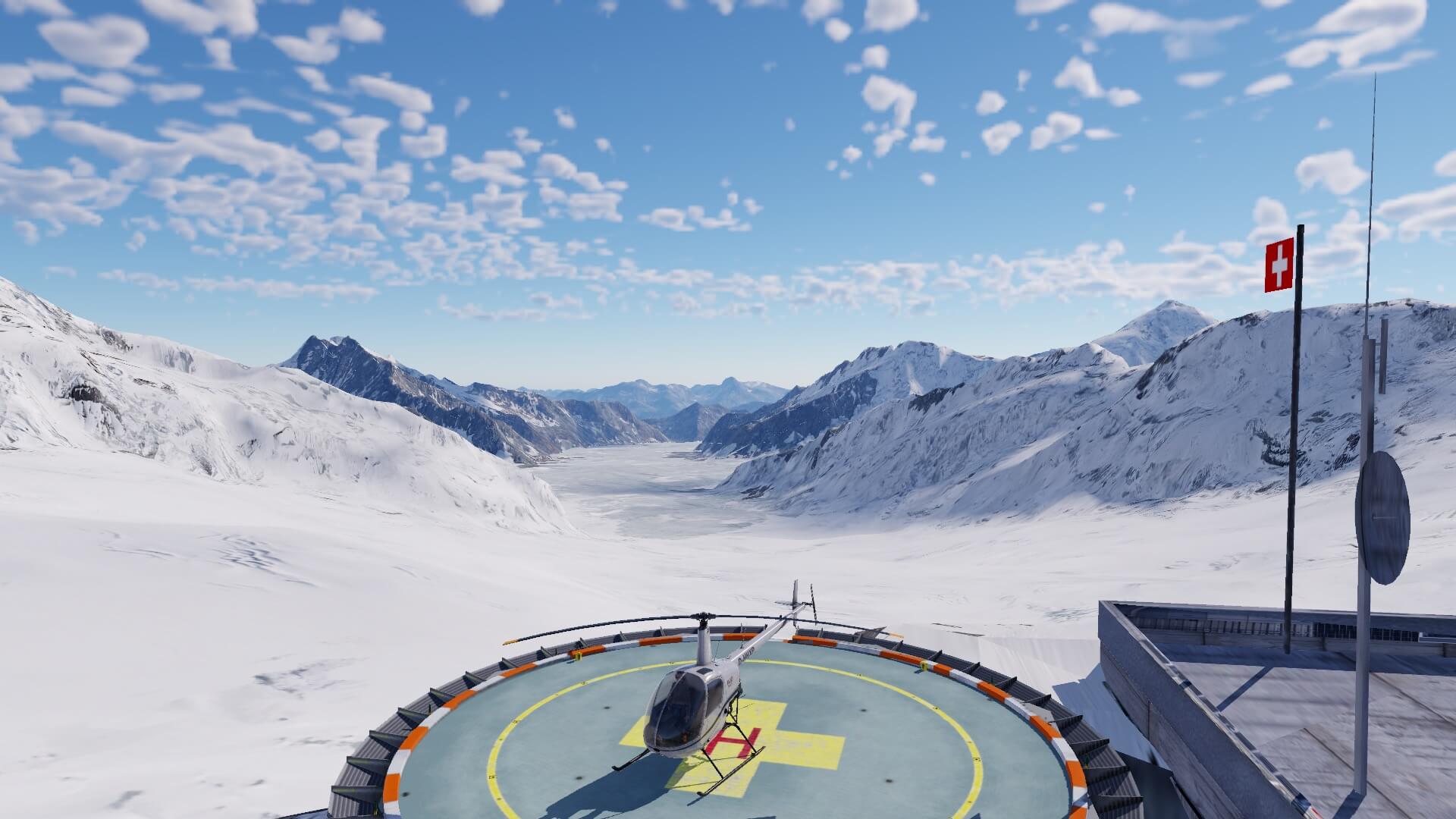
This will bring you and me to the highest railway station in Europe or actually, the Swiss people dare to say that this is the “top of Europe”. Can you remember that I quickly discussed during the comparison screenshots the city of Interlaken and the Eiger? This time we go together a bit further. We take the real train that will bring us passing the Eiger, then via Lauterbrunnen we take a special train that goes via a tunnel to the Jungfraujoch with a magnificent view on the Jungfrau, but in particular the Jungfrau-Aletsch-Bietschhorn which is on the world heritage website because it has the largest glacier in Europe with 9 mountains surrounding it that are higher than 4000 meters. Check out the following “promotional” movie from Swiss. Try to see the beauty of it!
And, did you like it?
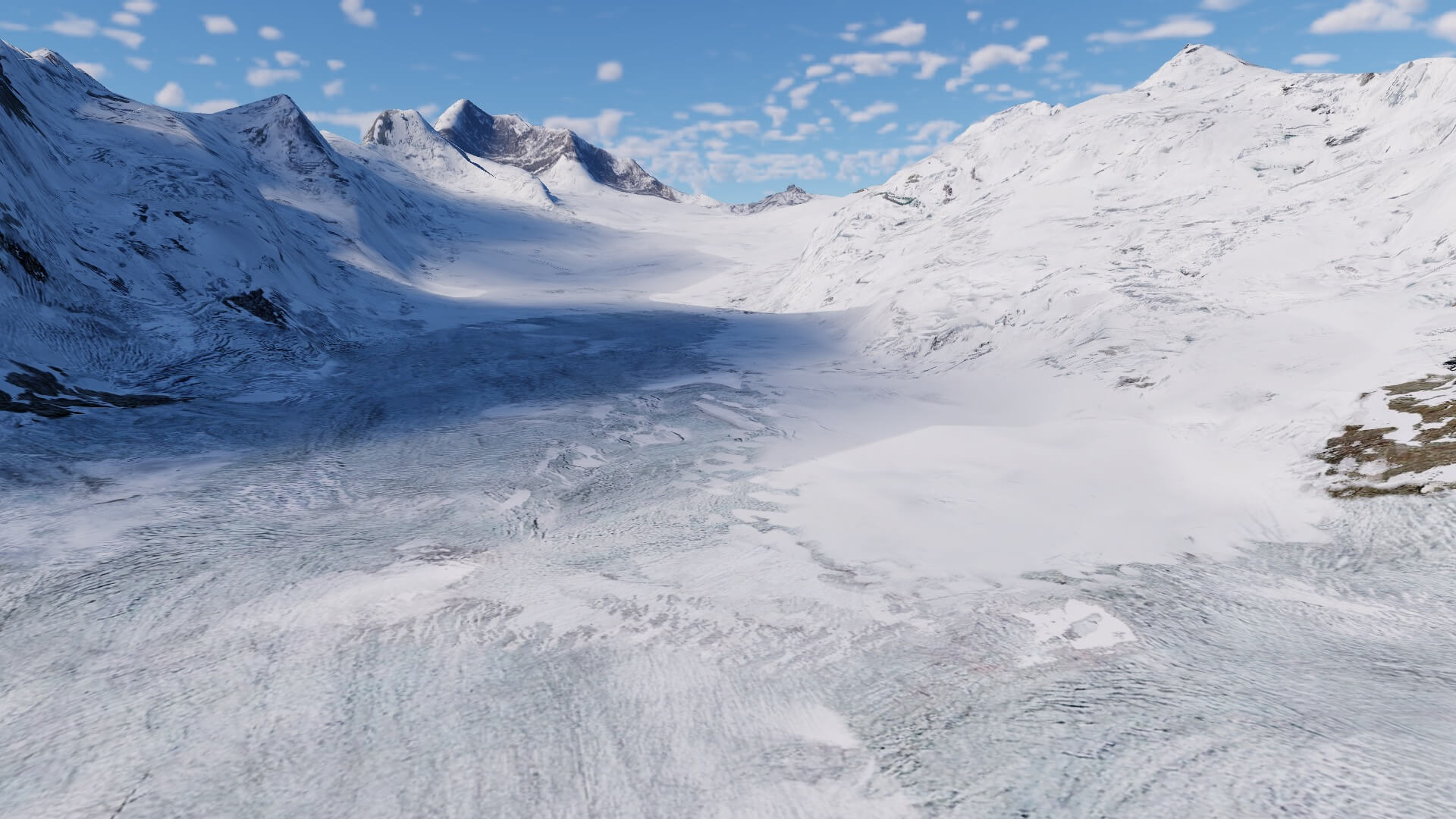
Great. Now we will visit the Jungfraujoch modeled by Frank and Fabio with their ALPS UHD XP12 and although I can’t do the whole trip from the Grindelwald valley up to the Jungfraujoch, I can highlight on my virtual route some places that are well modeled and not directly expected unless you take the time to explore all those tiny details that are sometimes almost hidden in the mountainous landscape.
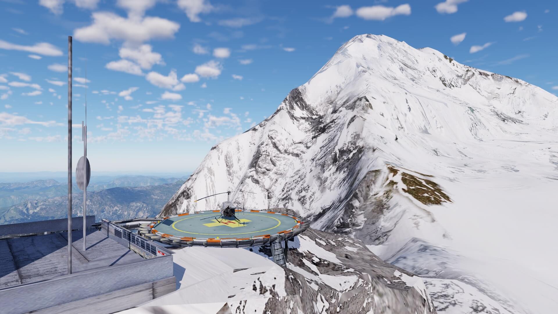
As you can see on the following screenshots, railway station Lauterbrunnen is well modeled with a spectacular view all around you, as it is in real too. From here we go up to the Jungfraujoch which is very well done and then I talk about the buildings you see, the helicopter platform, but in particular the awesome look at the Jungfrau and the huge Aletsch-Bietschhorn. As you can see on the screenshots, I made one screenshot from the highest railway station in Europe down into the Aletsch-Bietschhorn glacier and one from the other side of the Aletsch-Bietschhorn up to the railway station. Amazing how accurate this is and how real it all looks. No words for it to be honest!


And so I can continue with all of these awesome modeled objects. I could explore other places that are included in the ALPS UHD XP12 package, but I think with what I found and seen so far I can only come to one conclusion; I’m an unbelievable happy person!
And of course with every huge package there are always some small glitches to find, but when applicable, I informed Frank hoping that things can be modified and updated which will happen according to Frank.
I know, I didn’t cover every part of this huge 8000 km2 ALPS UHD XP12 package, but I leave something left for you to explore. The best to explore all these specific places is by using a small helicopter or when you can’t fly a helicopter, you can also use a ultra light model.
Summary
What else can I add in this summary? As it was with all their other mountain add-ons for X-Plane 11, this huge package with the Italian, France and Swiss Alps, is again a hit! This is typical a VFR add-on and the best to explore all the areas is by using a helicopter or ultra-light aircraft. The package comes with a bunch of airports, airfields and helipads, much more then the standard collection within X-Plane 12.
And as I always say “did I cover everything”, “did I see everything”. I can tell you, no way. Frank told me this “with a lot of patience I placed thousands of 3D objects, all self-built, and tried to improve the mountains by building 3D models with a lot of details”. With that in mind, there’s so much to see and so much left for you to explore. So therfore, can I use one word to express my thoughts, my feelings about ALPS UHD XP12? I would like to use one word, but I don’t know which one to use … awesome, gorgeous, stunning and so on. You got the message, right?
ALPS UHD XP12 from Frank and Fabio is available at the dedicated X-Plane.Org store page and cost you of this writing December 2022, 49.95 USD which includes a 10 USD discount as long as this offer is available.
Feel free to contact me if you’ve got additional questions related to this impression. You can reach me via email Angelique.van.Campen@gmail.com or to Angelique@X-Plained.com.
With Greetings,
Angelique van Campen
| Add-on: | Payware Frank Dainese and Fabio Bellini Mountain Scenery |
|---|---|
| Publisher | Developer: | X-Plane.Org | Frank Dainese and Fabio Bellini |
| Description: | Highly Realistic rendition of the French-Swiss-Italian Alps |
| Software Source / Size: | Download / Approximately 9,6MB (unzipped) |
| Reviewed by: | Angelique van Campen |
| Published: | December 18th 2022 |
| Hardware specifications: | - iMac Pro - Intel 3GHz Intel Xeon W / 4.5Ghz - Radeon Pro Vega 64 16368 MB - 64 GB 2666 MHz DDR4 - 1 internal shared 1TB SSD (Ventura 13.x) - 1 external 2TB LaCie Rugged Pro SSD (Bootcamp Windows 10) - Saitek Pro Flight System X-52 Pro and X-56 Rhino - Honeycomb Alpha Flight Controls - Honeycomb Bravo Throttle Quadrant |
| Software specifications: | - macOS Ventura (13.x) - X-Plane 11.5x - X-Plane 12 Early Access |
0 Comments